
Leinster Orienteering Championships 2018
Ajax are proud organisers of the 2018 Leinster Orienteering Championships in the Vale of Clara & Ballinastraw, Rathdrum, County Wicklow on Sunday February 25th 2018.
About us
AJAX is an orienteering club based in Dublin, Ireland... More
IOA Policy
Ajax Orienteering Club implements the Irish Orienteering Association's anti-doping, anti-discrimination, child-protection and land-access policies, details of which are available on www.orienteering.ie
AJAX Child Safeguarding Statement (CSS)
AJAX Child Safeguarding Statement (CSS)
News
Ajax Committee 2023
Chairman:
John O'Donovan
Secretary:
Oisin Wall
Treasurer:
Mike Long
Mapping:
Paul
Children and Liaison:
Donal Wickham
Equipment:
John DeLacy
Webmaster:
Marcus Geoghegan
Did you know?
You can use RSS to keep up to date with changes to the website. Use the RSS link at the bottom of this column with your favourite RSS reader.
Contact Ajax
Our Photostream
We have set up a Flickr account so that club members can share their photos on line. It also allows photos to be displayed on this website.
Useful Links


Copyright on all material lies with Ajax Orienteering Club or the original copyright holders. Permission should be sought before use.
Feb 29, 2012
Leinster Orienteering Championships 2012
LOC 2012, organised by AJAX, takes place on 30 Sep 2012 on 'Carraig Na Seabhac' ('Rock of the Hawks'). The competition area was to have been used for the Irish Championships last year, but in the end could not because of breeding Peregrine falcons and Merlins.
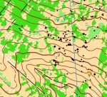
The terrain is a mixture of open mountain and dense thickets, with a wealth of rock features. The area is generally quite runnable but in places vegetation underfoot impedes progress. The map was surveyed in 2010/11 by Pat Healy.
The competiton area is bounded to the east by the Military road, to the south by the Glenmacnass waterfall, to the west by the Barnacullian ridge, and to the North by Carrigshouk mountain.
An LOC competition website will be setup before long.
20:55 | Permalink | Comments (0)
Feb 01, 2012
Dublin-by-Night, Slade Valley Woods, Feb 4th
The penultimate event of the 2011/2012 Dublin-by-Night league takes place this Saturday, February 4th, in Slade Valley Woods, County Dublin.
Location: Slade Valley Woods is the Northern part of the old Saggart Woods orienteering map that was used for many years for Leinster league events. It was last used for an orienteering event for a night-O in February 2008.
Directions: Drive south from Saggart Village (near Citywest Business Park) and pick up the signs for Slade Valley Golf Club. The route will NOT BE SIGNPOSTED, please follow the golf club signs - the event is very close to the golf club entrance. There is an alternative route via the N81 Blessington road, but again this will not be signposted.
Grid Ref = O 022 242
Lat/Lon = 53.25895 (north), -6.46729 (west)
Lat/Lan = 53°15'32" (north), 6°28'2" (west)
Loc8 = NT2-08-KT7
Parking: please only park on one side of the road and only park downhill from the registration car. Car pooling is encouraged.
Map: 1:7,500 with 5m contours, bagged in polypockets, A4 portrait, minor updates January 2012.
 Terrain: Typical Irish plantation forestry. There has been extensive felling in the area although some pockets of nice forest remain. There is some bramble and a lot of paths/roads. Due to recent rain some parts of the area are very muddy, especially forest roads used by nearby stables. In horse-racing parlance, the going in some places is “heavy”.
Timing: Sportident electronic timing will be used. Please make sure your sportident card is properly registered - it makes things a lot easier for the organisers. If you do not have a Sportident card, they will be available for hire for €2 each and you will be required to leave a deposit.
The start will not be manned, please organise yourselves and leave a reasonable time gap after the previous starter. The start and finish are in the same place.
Start Times & Course Closure: starts are from dark to 7PM. Control collection will commence at 8:15PM. You MUST report back to the download car even if you retire and do not finish the course. Failure to download might lead to an unnecessary search and you will be unwelcome at future Ajax Orienteering events.
Batteries: not included.
Moon Phase: waxing gibbous, high in the eastern sky.
Safety & Cancellation: This orienteering event does not visit open mountainside. However it is February and inclement weather should be expected - a rain jacket/cagoule might be mandatory. All competitors must carry a whistle. If you get hopelessly lost walk WEST along the forest roads until you reach the start/finish. If the weather on the day is severe there is always the possibility of the event being cancelled - if you are in doubt please check this website before travelling.
Under-16s: for insurance reasons under-16s are not permitted.
Novices: this event is not suitable for novice orienteers, instead you should plan on going to the orienteering event in Hellfire Wood on the morning of Sunday 5th, see the Setanta website for details.
Entry Form: please download the entry form and fill it in before travelling.
Control Descriptions: these will be printed on the front of the maps in IOF pictorial format. Loose control descriptions will NOT be available at the event - they are on the entry form (see link above). You can print them yourself or you can use the descriptions on the map. There will be no little bits of paper at the event!
Results: Live results will be available online - bookmark this page on your mobile phone so that you can see the results as they come in.
Long: 3.6km, 120m, 17 controls : experienced orienteers only
Short: 2km, 70m, 9 controls : experienced orienteers only
Planner: Marcus Geoghegan, Ajax
08:39 | Permalink | Comments (0)