
Leinster Orienteering Championships 2018
Ajax are proud organisers of the 2018 Leinster Orienteering Championships in the Vale of Clara & Ballinastraw, Rathdrum, County Wicklow on Sunday February 25th 2018.
About us
AJAX is an orienteering club based in Dublin, Ireland... More
IOA Policy
Ajax Orienteering Club implements the Irish Orienteering Association's anti-doping, anti-discrimination, child-protection and land-access policies, details of which are available on www.orienteering.ie
AJAX Child Safeguarding Statement (CSS)
AJAX Child Safeguarding Statement (CSS)
News
Ajax Committee 2023
Chairman:
John O'Donovan
Secretary:
Oisin Wall
Treasurer:
Mike Long
Mapping:
Paul
Children and Liaison:
Donal Wickham
Equipment:
John DeLacy
Webmaster:
Marcus Geoghegan
Did you know?
You can use RSS to keep up to date with changes to the website. Use the RSS link at the bottom of this column with your favourite RSS reader.
Contact Ajax
Our Photostream
We have set up a Flickr account so that club members can share their photos on line. It also allows photos to be displayed on this website.
Useful Links


Copyright on all material lies with Ajax Orienteering Club or the original copyright holders. Permission should be sought before use.
Oct 30, 2023
Vale of Clara Nature Reserve
Leinster League – Vale of Clara Nature Reserve, County Wicklow - Sunday November 5th 2023
The Vale of Clara Nature Reserve contains one of the largest stands of semi-natural native hardwoods in the country. The area has many paths and is rich in rock and contour detail. The nature reserve is bisected by a tributary of the Avonmore river. The stream has a steep slope on the southern side. The terrain and path network give many route-choice options.
Full details and the mandatory pre-entry form are here

18:36 | Permalink | Comments (0)
Jan 02, 2023
Night-O in St. Anne's Park, Jan 7th
Despite what it says in the details for the 3ROC Phoenix Park event, the first “Dublin by Night” event this year, is in fact the Ajax night-O in St. Anne’s Park, Raheny, taking place next Saturday, Jan. 7th.
The area is mixed park/woodland which is mostly runnable.
Parking: The St. Anne’s Tennis Club car park. The car park is opposite the junction of All Saints Road and Wade’s Avenue. The car park is in two sections and registration will be the SW corner of the lower car park (furthest from the entrance). Note that the entrance and exit to the car park are one-way.
Google Maps:
Apple Maps:
Toilets: There are no public toilets.
The start and finish are adjacent to registration which will be a car in the SW corner of the lower part of the car park.
Courses: There will be a long course (c. 5 km), and a short course (c. 2.5 km). Climb is negligible on both courses. Starts from 18:00 – 19:00. Courses close at 20:00.
SI Air, i.e. contactless punching, will not be enabled.
We hope to have the maps printed on waterproof paper but if not maps will be printed on ordinary paper and bagged.
Control descriptions will be on the map and will be available loose at registration
Juniors must be accompanied by an adult for the duration of their run.
We are not providing refreshments.
Anti-social behaviour: We have been informed by DCC that the park is occasionally the site of anti-social behaviour and have been requested to inform all our competitors of this. If you should be unfortunate enough to encounter such behaviour during the event, please do not approach any individuals involved, and instead contact the Gardaí and the organisers.
Online entries are open from 09:00 on Monday, Jan. 2nd. and will close at 23:59 on Friday, Jan. 6th.
20:31 | Permalink | Comments (0)
Oct 24, 2022
Leinster League - Carraig na Seabhac - Nov. 6th., 2022
Event Location:
The next Leinster League event, organised by Ajax Orienteering Club, takes place on Sunday, Nov. 6th. 2022, at Carraig Na Saebhac on the Old Military Road, Co. Wicklow. (Grid Reference: O 105 055).
Directions and Parking:
From the Sally Gap or Laragh follow the R115 and watch for the event signs. We will provide signs in the last 500 m before the turn off for parking.
Please car-share if possible.
Parking is on a forest road in the forest just to the north of Carrigshouk.
Over-flow parking, if necessary, will be on a forest road in Carrigeenduff, Forest on the east side of the R115 road. This may add a kilometre or more to the walk to the start. Please exercise care if walking on the R115.
Competition Area:
All courses will use the Carraig Na Seabhac map.
Terrain:
Carraig Na Seabhac lies in the upper Glenmacnass river valley. One side of the valley is forested with thickets of young pine and scattered pine trees; the other is open hillside. There is considerable rock feature throughout. The valley is divided by a stream (the upper section of the Glenmacnass River) which is crossable by foot. The terrain underfoot varies from rough heather to grass. There are some paths in the wooded part of the competition area, but no paths in the open hillside. The valley sides are moderately steep.
Generally boulders less than 2m in height are marked on the map with the small boulder symbol. The large boulder symbol is used for boulders larger than 2m in height. The rock pillar symbol (black area symbol) is used for very large boulders. In areas of pervasive rock detail boulders which seem small in relation to neighbouring boulders are not generally mapped. Crags are mapped both with, and without tags. The dark green screen (fight) is used to mark pine thickets and young plantation. The semi-open screen is used to map scattered trees. Lone trees are marked with a green dot symbol.
Map:
Maps will be printed on A4 water resistant paper, and are 1:10000, with 5m contours. The map was updated this year by Aonghus O'Cleirigh of Ajax.
Control Descriptions:
Control descriptions will be printed on the maps. Yellow and Red courses will have text descriptions only, Orange will have text and IOF descriptions, and all other courses will have IOF descriptions only. Loose descriptions will not be available at the event, but we will provide a download link for the descriptions a few days before the event.
Event Timing:
SportIdent (SI) timing will be used throughout. Contactless punching will NOT be enabled.
Participants must download their SI card at the registration tent in the parking area, whether they complete the course or not, otherwise we will not know if you have finished.
SI cards can be hired at registration for €2. Lost cards will be subject to a replacement charge. Remember to return your rented SI card when you have finished.
Course Details:
|
Course |
Length (km) |
Climb (m) |
Controls |
|
Yellow |
2.0 |
50 |
11 |
|
Orange |
3.2 |
100 |
15 |
|
Red |
3.8 |
120 |
18 |
|
Light Green |
3.4 |
105 |
12 |
|
Green |
5.3 |
155 |
12 |
|
Blue |
6.8 |
200 |
14 |
|
Brown |
8.2 |
235 |
17 |
Beginners:
All courses, including Yellow, take place in an area of rough and exposed ground and all have relatively steep climbs in places. As such this may not be the best area for those who are very new to the sport.
Yellow Course:
The Yellow course leaves paths in places but the route will be taped whenever this occurs.
None of the courses are suitable for buggies.
Start:
The start is exposed with no shelter but is adjacent to the finish. If not required to be carried, rain jackets they may be left here. We will provide some plastic sacks for this purpose. Note that they will not be transported to parking/registration, so don’t forget to collect them on your return from the finish. Ajax accepts no responsibility for any items left here by competitors.
Route to the Start:
The route from parking/registration will be taped, and is approximately 1.5 km, and 110 m climb, from the registration tent, over open ground. Aim to arrive approximately 10 minutes before your start time, to avoid unnecessary standing around in the cold.
Finish:
The finish is adjacent to the start and competitors will follow the same route to parking/registration that they used to get to the start. Remember to pick up any items you left at the start.
Download:
Download will be at the registration tent in the parking area. Competitors must download even if they did not complete their course.
Safety:
Whistles are compulsory.
In the event of bad weather rain jackets may also be compulsory. This will be posted at registration. Check the requirements before you leave for the start.
Full leg covering is required on all courses.
Whistles will be on sale at registration.
The Green, Blue and Brown courses all cross the Glenmacnass river, which can swell significantly after periods of heavy rainfall and should be crossed with care.
Orienteering is an adventure sport. You take part at your own risk.
Event Officials:
Planner: John O’Donovan (Ajax)
Controller: Donal Wickham (Ajax)
Organiser: Paul (Ajax)
20:48 | Permalink | Comments (0)
Feb 20, 2022
Leinster League – Vale of Clara - 27th February
Event Location: Leinster League No.2 of 2022 will be held on Sunday 27 February 2022 at the Vale of Clara Nature Reserve, Rathdrum, Co. Wicklow..
Event Directions and Parking: Parking and registration are in Ballygannon Wood (Grid Reference: T 184 896). Ballygannon Wood is 1k north of Rathdrum village on the R755 (Rathdrum to Laragh road).
Parking in Ballygannon Wood is limited and single occupant cars will be asked to park in Rathdrum and either carpool and return to Ballygannon or park and walk. The recommended walking route from Rathdrum to Ballygannon is by following the Jubilee Loop walk. On street parking is available around the junction of Poundbrook Lane and The Woods in Rathdrum. Access to the Jubilee Loop walk is off Poundbrook Lane at Grid Reference T 18330 88741 and the walking route will be taped from the entry point to Ballygannon Wood to the parking. The walk from the Poundbrook Lane/The Woods junction is 1.5k (15-20 minutes walking) to the parking.
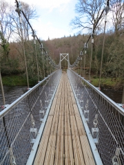 Start/Finish: There is a 10 minute walk (700m) from the registration to the start and a 10 minute walk from the finish back to registration where download will be available. The start and finish are reasonably close to one another so jackets could be left at the start for collection after the finish if required. The route to the start and back from the finish involves crossing the new pedestrian bridge across the Avonmore River – please do not let children shake or bounce on the bridge.
Terrain: The Vale of Clara Nature Reserve contains one of the largest stands of semi-natural native hardwoods in the country. The area has many paths and is rich in rock and contour detail. The nature reserve is bisected by a tributary of the Avonmore river. The stream has a steep slope on the southern side. The terrain and path network give many route-choice options. Runability underfoot in ‘white’ forest is generally fast. In places, bilberry bushes can impede running speed. Where running speed is significantly impacted by bilberry growth the ‘undergrowth – slow running’ screen is used to indicate this. Where bilberry growth is particularly dense the ‘undergrowth – walk’ screen is used. There are virtually no brambles in the forest.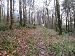
Map: Maps are printed on water-resistant material at a scale of 1:10,000 for all courses on A4 paper. Contour interval is 5 meters.
Control descriptions: Control descriptions are printed on the front of your map or can be downloaded here. They will be not be available at the start.
Registration and Entry Fees: Entry is via the IOA pre-entry system only – there will be no entry on the day.
Adult: €8
Junior/Full-time Student/OAP/Concession: €5
Family: €20
Timing: SportIdent (SI) timing will be used. Hired SI cards can be collected at event registration. You must download your SI card after orienteering, whether you complete the course or not. Otherwise, we will not know if you have finished. The event will not use SIAC punching.
Start-times: 10:30 – 12:30.
Courses close: 14:30.
Event Officials:
Planner: John O’Donovan
Organiser: Donal Wickham
Controller: Marcus Geoghegan
Brown – 10.9k, 435m climb, 26 Controls
Blue – 7.5k, 260m climb, 19 Controls
Green – 5.0k, 175m climb, 19 Controls
Light Green – 3.8k, 105m climb, 13 Controls
Red – 4.1k, 85m climb, 13 Controls
Orange - 3.5k, 75m climb, 12 Controls
Yellow – 2.4k, 40m climb, 11 Controls
Refreshments (Tea/Coffee) will be available at the Registration area – please bring your own cup as none will be available on the day.
Important: Please follow the country code and leave no trace principles. Please bring all of your rubbish home with you – don’t leave it to the organisers to dispose of full rubbish bags.
Thanks to the National Parks and Wildlife Service for permission to use the Vale of Clara Nature Reserve and to Coillte for granting permission to park on their land.
15:02 | Permalink | Comments (0)
Nov 27, 2021
Featherbeds Leinster League Nov 28th 2021
The next Leinster League event of the 2021 season is on November 28th 2021 in the Featherbeds/Glendoo area, County Dublin. (Grid Reference: O 131 196).
Event Directions and Parking: The event is signposted from the R115 (Military Road), the road from Dublin to the Sally Gap. The road passes through the competition area. Parking, registration, start and finish are adjacent to the R115.
Competition Area: The competition area comprises part of the Glendoo map north of the R115 and part of Featherbeds area south of the R115. The area consists of gently sloping open hillside with detailed turf cuttings and some paths. There are many water holes, some of which are not mapped. Runnability varies from medium to very slow. Here's a RouteGadget of the most recent Leinster League event on this map (2017).
 Map: The map is printed on A4 water resistant paper at a scale of 1:7,500 for all courses. Contour interval is 5 meters. The map is aligned to magnetic North. Plastic bags will be available at the start.
Beginners: This event is suitable for people of all ages who are new to orienteering. You must pre-enter here use the Enter Now link. If you are new to orienteering please let the organisers know and they will show you what to do. Unfortunately, due to the nature of the terrain, this event is not buggy friendly.
Fees:
Adult: €8
Junior/Full-time Student/OAP/Concession: €5
Family: €20 (max 2 adults and no more than five family members in total)
Groups:
If you plan to bring a large group please email ajax@orienteering.ie well in advance of the event - we need to make sure we have enough pre-printed maps for you and if you're bringing a bus we need to make parking arrangements.
Timing:
Start-times are between 11:00 – 12:30.
Courses will close at 14:30 - you must report to the finish before then, even if you do not complete your course.
SportIdent (SI) timing will be used. SI cards are available for hire at event registration for €2. You must download your SI card at the download station after orienteering, whether you complete the course or not. Otherwise the event organisers will not know if you have finished. Sportident air punching will not be enabled.
Course Details:
Brown – 8km, 100m, 22 controls
Blue - 6.3km, 70m, 23 controls
Green – 5.2km, 60m, 19 controls
Light Green – 2.8km, 25m, 17 controls
Red – 3.4km, 25m, 15 controls
Orange - 2.4km, 10m, 13 controls
Yellow - 2.3km, 10m, 13 controls
Crossing the R115: From the parking area all competitors must cross the R115 to reach the start and finish. Please follow the directions of race marshals. Competitors on the Brown, Blue and Green courses cross the R115 twice while competing. Great care must be taken when crossing the road. Road traffic has right of way! Competitors on the Yellow, Orange, Red and Light Green courses do not cross the R115 while competing.
Control Descriptions: IOF Control descriptions are not printed on the map for all courses. Loose control descriptions will be available for all courses at registration. Control descriptions can be downloaded here. Text yellow descriptions here.
Results will be published on www.orienteering.ie
Event Officials:
Organiser: Rory Wallace
Planner: John O'Donovan
Controller: Donal Wickham
Acknowledgements: Ajax Orienteering club are grateful to the Wicklow Mountains National Park for permission to hold this event.
Important: Orienteering is an adventure sport. You take part at your own risk and you are responsible for your own safety. In the event of inclement weather this event may be cancelled at short notice - check this website before travelling. The organisers may require you to carry a rain jacket so please come prepared. Whistles are compulsory (there may be a limited number available for sale at the event).
Dogs: The Wicklow uplands is sheep country - dogs must be kept on a leash and confined to the parking/assembly area. Dogs are not permitted in the competition area - please respect this rule.
Litter: Please bring you waste home with you - do not expect the organisers to take it away for you.
Covid-19: Please study the Irish Orienteering Association's Covid-19 guidelines carefully and pay special attention to the Participant Code of Conduct.
08:16 | Permalink | Comments (0)
Nov 21, 2021
Featherbeds Leinster League Nov 28th 2021
The next Leinster League event of the 2021 season is on November 28th 2021 in the Featherbeds/Glendoo area, County Dublin. (Grid Reference: O 131 196).
Event Directions and Parking: The event is signposted from the R115 (Military Road), the road from Dublin to the Sally Gap. The road passes through the competition area. Parking, registration, start and finish are adjacent to the R115.
Competition Area: The competition area comprises part of the Glendoo map north of the R115 and part of Featherbeds area south of the R115. The area consists of gently sloping open hillside with detailed turf cuttings and some paths. There are many water holes, some of which are not mapped. Runnability varies from medium to very slow. Here's a RouteGadget of the most recent Leinster League event on this map (2017).
Map: The map is printed on A4 water resistant paper at a scale of 1:7,500 for all courses. Contour interval is 5 meters. The map is aligned to magnetic North.
Beginners: This event is suitable for people of all ages who are new to orienteering. You must pre-enter here - use the Enter Now link. If you are new to orienteering please let the organisers know and they will show you what to do. Unfortunately, due to the nature of the terrain, this event is not buggy friendly.
Fees:
Adult: €8
Junior/Full-time Student/OAP/Concession: €5
Family: €20
There will be a €2 surcharge for any participant who is not already a member of an orienteering club. The surcharge will be waived if the participant registers with Ajax Orienteers at the event. (Membership is free for the first year).
Groups:
If you plan to bring a large group please email ajax@orienteering.ie well in advance of the event - we need to make sure we have enough pre-printed maps for you and if you're bringing a bus we need to make parking arrangements.
Timing:
Start-times are between 11:00 – 13:00.
Courses will close at 15:00 - you must report to the finish before then, even if you do not complete your course.
SportIdent (SI) timing will be used. SI cards are available for hire at event registration for €2. You must download your SI card at the download station after orienteering, whether you complete the course or not. Otherwise the event organisers will not know if you have finished. Sportident air punching will not be enabled.
Course Details:
Brown 9.0k 150m 30 Controls
Blue 6.6k 100m 22 Controls
Green 4.7k 60m 20 Controls
Light Green 3.3k 30m 17 Controls
Red 3.5k 30m 16 Controls
Orange 2.9k 25m 13 Controls
Yellow 2.2k 20m 12 Controls
Crossing the R115: From the parking area all competitors must cross the R115 to reach the start and finish. Please follow the directions of race marshals. Competitors on the Brown, Blue and Green courses cross the R115 twice while competing. Great care must be taken when crossing the road. Road traffic has right of way! Competitors on the Yellow, Orange, Red and Light Green courses do not cross the R115 while competing.
Control Descriptions: IOF Control descriptions are not printed on the map for all courses. Loose control descriptions will be available for all courses at registration. Text versions will be available for the Yellow, Orange and Red courses.
Results will be published on www.orienteering.ie
Event Officials:
Organiser: Rory Wallace
Planner:
Controller:
Acknowledgements: Ajax Orienteering club are grateful to the Wicklow Mountains National Park for permission to hold this event.
Important: Orienteering is an adventure sport. You take part at your own risk and you are responsible for your own safety. In the event of inclement weather this event may be cancelled at short notice - check this website before travelling. The organisers may require you to carry a rain jacket so please come prepared. Whistles are compulsory.
Dogs: The Wicklow uplands is sheep country - dogs must be kept on a leash and confined to the parking/assembly area. Dogs are not permitted in the competition area - please respect this rule.
Litter: Please bring you waste home with you - do not expect the organisers to take it away for you.
Covid-19: Please study the Irish Orienteering Association's Covid-19 guidelines carefully and pay special attention to the Participant Code of Conduct.
21:39 | Permalink | Comments (0)
Jul 29, 2020
Marlay Park CATI
Marlay Park CATI - 9th August 11am to 1pm
Event Location: Marlay Park.
AJAX is delighted to be hosting a Come and Try It event in Marlay Park on the 9th August! We look forward to seeing you all there.
Event Directions and Parking: Parking is available at the car park just off College Road on the south side of the park. An orienteering kite will be placed at the car park entrance. Registration, start, finish and download will all be based near this car park.
https://goo.gl/maps/parBMveAuoYrAU2J7
Map: Maps are printed at a scale of 1:5,000 for all courses on A4 paper. Contour interval is 5 meters. There will be no loose control descriptions at the event. Either use the descriptions that are printed on the front of your map, or download them from the link below and print them yourself.
Registration and Entry Fees: Registration will be in the car park just off College Road. If you are new to orienteering, please let the organisers know and they will show you what to do. Please get in touch beforehand if you are bringing a large group so we can arrange maps and especially if you are bringing a bus. Please pre-enter at:
https://www.orienteering.ie/fixtures/marlay-park-7/
Adult: €8
Junior/Full-time Student/OAP/Concession: €5
Family: €20
Entries close at 6pm on Saturday 8th August. The entry is per map so please just enter one person if you are planning to run together with one map.
There will be a €2 surcharge for anyone not already a member of an orienteering club. The surcharge will be waived if the participant registers with Ajax Orienteers at the event. (Membership is free for the first year).
COVID 19: By attending the event you are confirming that:
- you do not have any COVID-19 symptoms,
- you were not in contact in the last 14 days with someone who has Covid-19 symptoms,
- you are not required to self-isolate
- you have not been outside Ireland in the past 2 weeks.
Please follow the IOA Participant Code of Conduct at all times.
Unfortunately, we cannot provide refreshments but there are cafes and market stalls in the park.
Timing: SportIdent (SI) timing will be used. SI cards are available for hire at event registration for €2. You must download your SI card after orienteering, whether you complete the course or not. Otherwise, we will not know if you have finished.
Start-times: 11:00 – 13:00.
Courses close: 15:00.
Oganiser: John O’Donovan
Course Details:
Long – 6.4 k, 17 controls
Medium – 3.7 k, 16 controls
Short – 2.2 k, 10 controls
Please bring all of your rubbish home with you – don’t leave it to the organisers to dispose of full rubbish bags. Thanks to DLRCC for granting permission to use the park.
12:17 | Permalink | Comments (0)