
Leinster Orienteering Championships 2018
Ajax are proud organisers of the 2018 Leinster Orienteering Championships in the Vale of Clara & Ballinastraw, Rathdrum, County Wicklow on Sunday February 25th 2018.
About us
AJAX is an orienteering club based in Dublin, Ireland... More
IOA Policy
Ajax Orienteering Club implements the Irish Orienteering Association's anti-doping, anti-discrimination, child-protection and land-access policies, details of which are available on www.orienteering.ie
AJAX Child Safeguarding Statement (CSS)
AJAX Child Safeguarding Statement (CSS)
News
Ajax Committee 2023
Chairman:
John O'Donovan
Secretary:
Oisin Wall
Treasurer:
Mike Long
Mapping:
Paul
Children and Liaison:
Donal Wickham
Equipment:
John DeLacy
Webmaster:
Marcus Geoghegan
Did you know?
You can use RSS to keep up to date with changes to the website. Use the RSS link at the bottom of this column with your favourite RSS reader.
Contact Ajax
Our Photostream
We have set up a Flickr account so that club members can share their photos on line. It also allows photos to be displayed on this website.
Useful Links


Copyright on all material lies with Ajax Orienteering Club or the original copyright holders. Permission should be sought before use.
May 12, 2009
Back to the Future
Marcus has slipped back in time into the analog world to gather up contours in the 1980s from Cronybyrne. When he comes back he’s going to turn them into 1’s and 0’s for us to use. This is his report to date…..
 Peter Gargan found the eight colour separations at 1:7500 that were sent to the printer in the '80s. They are Eoin Rothery masterpieces. I have talked to Pat Healy and he says that his 1993 revision just used the '80s map as a template with vegetation updates overlaid, so the brown (contour), black (road, boulder) and even most of the blue separations are still valid.
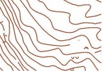
I have been experimenting with raster (bitmap) to vector-bezier (OCAD) conversion and have had great success on my trial scans with some software called wintopo. The picture shows some of Cronybyrne’s contours after conversion to OCAD vector format.
The colour separations have been professionally scanned by a friend of Brian Hollinshead who did a huge amount of large format high quality scanning for the Trinity map archive project. My next job is to convert the black, brown and blue into OCAD vector-bezier and we should have a good base to start updating green and yellow in field surveys. Of course the non-contour brown, the blue, and the black road/path network will need to be checked at the same time.
I hope to be able to report some progress in the next couple of weeks, although I would beg some patience from Ajax as May is the busiest time for me with my *two* IOA hats on.
16:18 | Permalink | Comments (0)
The comments are closed.