
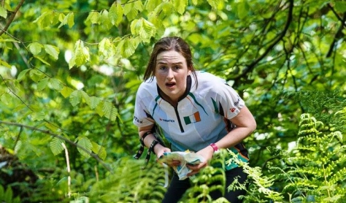
Leinster Orienteering Championships 2018
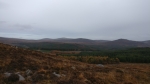
Ajax are proud organisers of the 2018 Leinster Orienteering Championships in the Vale of Clara & Ballinastraw, Rathdrum, County Wicklow on Sunday February 25th 2018.
About us
AJAX is an orienteering club based in Dublin, Ireland... More
IOA Policy
Ajax Orienteering Club implements the Irish Orienteering Association's anti-doping, anti-discrimination, child-protection and land-access policies, details of which are available on www.orienteering.ie
AJAX Child Safeguarding Statement (CSS)
AJAX Child Safeguarding Statement (CSS)
News
Ajax Committee 2023
Chairman:
John O'Donovan
Secretary:
Oisin Wall
Treasurer:
Mike Long
Mapping:
Paul
Children and Liaison:
Donal Wickham
Equipment:
John DeLacy
Webmaster:
Marcus Geoghegan
Did you know?
You can use RSS to keep up to date with changes to the website. Use the RSS link at the bottom of this column with your favourite RSS reader.
Contact Ajax
Our Photostream
We have set up a Flickr account so that club members can share their photos on line. It also allows photos to be displayed on this website.
Useful Links


Copyright on all material lies with Ajax Orienteering Club or the original copyright holders. Permission should be sought before use.
Oct 29, 2019
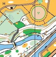
Leinster League – Vale of Clara - 10th November
Event Location: The next Leinster League event will be held on Sunday 10 November 2019 at the Vale of Clara, Co. Wicklow. (Grid Reference: T 201 909).
Event Directions and Parking: Signposted from the eastern side of Rathdrum on the R752 road to Glenealy. Parking and registration are in Ballinastraw Coillte land.
https://goo.gl/maps/Rzvr4swkSUP7Qtik8
There will be a 20 minute walk from the registration to the start and a 20 minute walk from the finish back to registration where download will be available. The start and finish are close to one another so jackets can be left at the start for collection after the finish. Please note that you will have to cross a road to reach the start and again after the finish. There will be signs warning the oncoming cars but please take care. Do not park near the start as it is too narrow and would be unsafe.
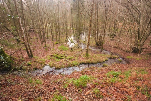
Photo: Paul
Terrain: The Vale of Clara Nature Reserve contains one of the largest stands of semi-natural native hardwoods in the country. The area has many paths and is rich in rock and contour detail. The nature reserve is bisected by a tributary of the Avonmore river. The stream has a steep slope on the southern side. The terrain and path network give many route-choice options. Runability underfoot in ‘white’ forest is generally fast. In places, billberry bushes can impede running speed. Where running speed is significantly impacted by billberry growth the ‘undergrowth – slow running’ screen is used to indicate this. Where billberry growth is particularly dense the ‘undergrowth – walk’ screen is used. There are virtually no brambles in the forest.
Map: Maps are printed on water-resistant material at a scale of 1:10,000 for all courses on A4 paper. Contour interval is 5 meters. The longer courses are contained in a relatively small area so competitors are advised to carefully check that they are navigating to the correct next control.
Control descriptions: There will be no loose control descriptions at the event. Either use the descriptions that are printed on the front of your map, or download them from the link below and print them yourself.
VoCNR LL 10-Nov-19 V5 Descriptions.pdf
Registration and Entry Fees: Enter at the event. If you are new to orienteering, please let the organisers know and they will show you what to do. Please get in touch beforehand if you are bringing a large group so we can arrange maps and especially if you are bringing a bus.
Adult: €8
Junior/Full-time Student/OAP/Concession: €5
Family: €20
There will be a €2 surcharge for anyone not already a member of an orienteering club. The surcharge will be waived if the participant registers with Ajax Orienteers at the event. (Membership is free for the first year).
Timing: SportIdent (SI) timing will be used. SI cards are available for hire at event registration for €2. You must download your SI card after orienteering, whether you complete the course or not. Otherwise, we will not know if you have finished.
Start-times: 11:00 – 13:00.
Courses close: 15:00.
Event Officials:
Controller: Mike Long
Planner: Marcus Geoghegan
Organiser: John O’Donovan
Course Details:
Brown – 7.6 k, 275m climb
Blue – 5.9 k, 200m climb
Green – 4.5 k, 150m climb
Light Green – 3.3 k, 90m climb
Red – 5.3 k, 75m climb
Orange - 2.4 k, 70m climb
Yellow – 2.1 k, 50m climb
Important: Please follow the country code and leave no trace principles. Please bring all of your rubbish home with you – don’t leave it to the organisers to dispose of full rubbish bags. Thanks to Coillte for granting permission to park in their land. Please bring reusable cups if you can to cut down on waste.
23:23 | Permalink | Comments (0)
May 10, 2019
Irish Orienteering Championships 2019
 Fermanagh Orienteers and Lagan Valley Orienteers were the organisers of this years IOC, held over the May holiday weekend. The weather was perfect for racing, not cold and wet, and not so warm that dehydration became a factor.
The sprint race (day 1) was held on the Florencecourt Estate, Fermanagh. The terrain used was a mixture of urban detail, parkland and forest. This was a departure from most sprint events where urban terrain is predominantly used. It was a fine event, and a good orienteering experience.
The middle distance race (day 2) was on the shore of Lough Erne, at Castle Archdale. The courses were fast and offered plenty of route choice. The arena was in the impressive castle courtyard where competitors raced up and down flights of steps to reach the finish kite.
Day 3, the classic distance race was held in the Cavan Burren Park, in the area first used for IOC 1994. The complex mixture of forest and open land provided plenty of technical challenge. The courses had everything - fine navigation in complex forest with undergrowth and low visibility, fast running on intricate open limestone terrain and myriad route-choice.
 The relay (day 4), organised by LVO, was held in Parkanaur, a recreational forest park near Dungannon. The terrain allowed for fast running with interesting vegetation details which influenced route choice.
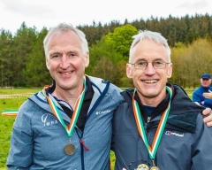
Ajax podium finishers
(Roisin and Ruairi Long competed for their university club (UCDO) at the championships, but we are still claiming them as our own!!!)
Sprint (Day 1) – Florencecourt, Fermanagh
First: M20E Ruairi Long
Second: W21E Roisin Long
Middle Distance (Day 2) – Castle Archdale, Fermanagh
First: M20E Ruairi Long, M55 Aonghus O'Cleirigh
Second: M12 Cian Wickham
Third: W21E Roisin Long
Classic Distance (Day 3) – Burren Park, Cavan
First: M20E Ruairi Long, M55 Aonghus O'Cleirigh
Third: W21E Roisin Long
Relay (Day 4) – Parkanaur, Tyrone
First: H12 Aonghus O'Cleirigh, Paul, Mike Long
Roisin Long finished in the winning Premier Women's Open Class team representing UCDO, a fantastic result! Ruairi Long finished in the third placed Premier Men's Open Class team representing UCDO, again a great result.
20:22 | Permalink | Comments (0)
Mar 13, 2019
Bushy Park, March 18th, Come-and-try-it Orienteering
Ajax Orienteering Club are holding a Come-and-try-it event this coming Bank Holiday Monday in Bushy Park, Templeogue on Monday, March 18th., 2019.
Note the unusual date!
Event Officials:
Organiser: Paul
Planner: Paul
Organiser: Paul
Planner: Paul
Directions & Parking:
The main entrance to the park is on Rathdown Avenue. After you turn off Templeogue Road onto Rathdown Avenue you will quickly come to a small roundabout. Continue straight through the roundabout and the main entrance is about 200 metres further, on the right hand side.
Parking for the event is also on Rathdown Avenue. Please be aware that one side of the road is pay and display parking. The other side of the road is available for parking but sections of it have double yellow lines. Please do not obstruct access in any way for local residents or other park users.
Bear in mind that as it is a bank holiday it will likely be busy. Please car pool etc., if possible.
You can also access the park from Springfield Ave. where there is also some parking.
Apple Maps is showing me that the 15, 49, 65 and 65B stop nearby, but you should confirm details on the CIE website if you are planning on travelling to the event by bus. Also bear in mind that bank holiday schedules will be in effect.
Registration:
Registration will be in the vicinity of the bandstand at the southern end of the Lake. From the entrance beside the tennis courts proceed straight along the side of the courts and then continue on the path down the hill to the bandstand. We are hoping to use the bandstand itself for registration and if so you are welcome to leave gear, bikes etc. there.
Start Times:
Starts are from 11:00 to 13:00 and courses close at 14:00 sharp.
Starts are from 11:00 to 13:00 and courses close at 14:00 sharp.
Fees:
Adult: €8
Junior/Full-time Student/OAP: €5
Family: €20
Adult: €8
Junior/Full-time Student/OAP: €5
Family: €20
SportIdent:
SportIdent timing will be in use and SI cards are available for rent at €2 per card.
Map & Courses:
There are two courses, one is a scatter format, and the other is a score format. Both use the same controls.
Scatter:
The mass start for the scatter will be at 12:00. There are 20 controls, and there are three variations:
Short Scatter: Get any 10 controls.
Medium Scatter: Get any 14 controls.
Long Scatter: Get any 18 controls.
Score:
You can enter and start the Score event anytime between 11:00 and 13:00. There are two variations:
Elite Score: 25 minute time limit.
Standard Score: 40 minute time limit.
Get as many controls as you can within the time limit. All controls are worth 10 points. Penalty is 10 points per minute late.
Mapping Notes:
The map is 1:4000 with 2.5 metre contours and has been not been updated since it’s last use in January of 2018.
As it is Winter some areas that would be difficult to pass through during the Summer may be passable now. This is not reflected in the map.
Small man-made objects such as signage, bike racks, rubbish bins etc. have not been mapped. Goalposts are also not shown on the map. Park benches have been mapped using the man-made X symbol. In the forested areas there are often many very small paths which have not been mapped. The rootstock symbol (green X) has been used to indicate both rootstocks and large logs lying on the ground. In some cases the rootstocks may be quite high. Where a number of logs are piled together they may also be indicated by a single rootstock symbol. Along much of the park parallel to the river there is a short steep drop indicated only by the contours. You may be surprised by just how steep this is. Take care descending.
If crossing by the weir, expect to get your feet wet. Take care when crossing.
Control Descriptions:
Control descriptions are in IOF pictorial format and will be printed on the map as well as being available loose at registration. English format descriptions will also be available loose but will not be on the map.
Refreshments:
We hope to provide light refreshments after the event.
Toilets:
There are toilets available in the Bushy Park Tennis and Padel building beside the courts, and tea/coffee can be purchased there as well. Absolutely no mucky gear or spikes inside the building.
Results:
Results will be published on www.orienteering.ie
Results will be published on www.orienteering.ie
Acknowledgements:
Ajax Orienteering club are grateful to Dublin City council for permission to hold this event in the park.
Paul
10:22 | Permalink | Comments (0)
Mar 03, 2019
Leinster League - Bull Island - 10th March
Event Location: The next Leinster League event will be held on Sunday 10 March 2019 on Bull Island, Dublin. (Grid Reference: O 234 370).
Event Directions and Parking: Signposted from the coast road (James Larkin Road). Parking, registration, start and finish are near the interpretive center at the end of the causeway.
 Terrain: Grass-covered sand dunes with many small paths, isolated trees and man-made features. Marshes are a little wet in places.
Map: Maps are printed on water resistant material at a scale of 1:5,000 for all courses. The map shows the island in two sections laid out side-by-side on an A3 sheet. Contour interval is 2.5 meters. Power lines are not displayed and the magnetic grid lines run 45 degrees to the edge of the map. The Brown course uses a modified map with only contour and marsh detail displayed. Control descriptions for all courses will be available at registration and will also be printed on the map. The Yellow course has a taped route on one leg.
Registration and Entry Fees: Enter at the event. If you are new to orienteering please let the organisers know and they will show you what to do.
Adult: €8
Junior/Full-time Student/OAP/Concession: €5
Family: €20
There will be a €2 surcharge for anyone not already a member of an orienteering club. The surcharge will be waived if the participant registers with Ajax Orienteers at the event. (Membership is free for the first year).
Timing: SportIdent (SI) timing will be used. SI cards are available for hire at event registration for €2. You must download your SI card after orienteering, whether you complete the course or not. Otherwise we will not know if you have finished.
Start-times: 11:00 – 13:00.
Courses close: 15:00.
Event Officials:
Controller: Donal WickhamPlanner: Aonghus O’Cleirigh
Oganiser: Anna Musial
Course Details:
Brown – 8.8 k, 30 controls, (contours/marsh only)Blue - 8.3 k, 29 controls
Green – 5.1 k, 29 controls
Light Green – 3.7 k, 23 controls
Red – 3.7 k, 28 controls
Orange - 2.5 k, 21 controls
Yellow - 1.6 k, 15 controls
Important: Bull Island is an EU designated Special Area of Conservation. Please do not cause damage or litter. Thanks to Dublin City Council for granting permission to hold the event.
14:55 | Permalink | Comments (0)
Nov 28, 2018
Race Report - Carraig na Seabhac - Nov. 4th., 2018
This is an extremely late race report on the 10th Leinster League Event Ajax organised. We were very lucky with the weather in Carraig na Seabhac that Sunday and even the rain stayed away until the event had finished.
This Year we decided to run two courses, yellow and orange on Carrigeenduff Wood, which is in the end of CNOC’s Scar map. All other courses run on Carraig na Seabhac map.
A total of 85 participants were orienteering that day. Congratulations to everyone, who despite of the event fame, seen as being difficult technically and in rough terrain were brave enough to participate!
Many thanks to our wonderful volunteers for all the hard work!
Results: http://www.orienteering.ie/result2?oaction=fullSIResult&a...
Route Gadget: http://www.orienteering.ie/gadget/cgi-bin/reitti.cgi?act=...
Out next event is Dublin by Nigh on 2nd February 2019 in Rockbrook. Have a look here for more details. We hope to see you there!
10:20 | Permalink | Comments (0)
Oct 28, 2018
Leinster League - Carraig na Seabhac - Nov. 4th., 2018
 Event Location: The next Leinster League event (#10) is being organised by Ajax Orienteering Club, and will take place on Sunday, Nov. 4th. at Carraig Na Sebhac and Carrigeenduff on the Old Military Road in Co. Wicklow. (Grid Reference: O 105 055).
Event Directions and Parking: The event will be sign-posted from the Sally Gap and Laragh (see https://maps.google.com/?q=53.
Parking is on a forest road. Please car-share if possible as there is a limited amount of parking.
Competition Area: The Orange and Yellow courses will use the north end of CNOC's Scarr Map (Carrigeenduff Wood) with their start close to registration and the Military Road. Ajax are very grateful to CNOC for permission to use their map.
All other courses will use the Carraig Na Seabhac map.
Terrain: Carraig Na Seabhac lies in the upper Glenmacnass river valley. One side of the valley is forested with thickets of young pine and scattered pine trees; the other is open hillside. There is considerable rock feature throughout. The valley is divided by a stream (the upper section of the Glenmacnass River) which is crossable by foot. The terrain underfoot varies from rough heather to grass. There are some paths in the wooded part of the competition area, but no paths in the open hillside. The valley sides are moderately steep.
Carrigeenduff lies at the North end of the CNOC map of Scarr. It is an area of mixed coniferous forest with numerous clearings, rides and tracks.
 Map: The Carraig Na Seabhac map for the senior courses was surveyed in 2010-2011 by Pat Healy and partially updated in 2012, 2014 and 2016. Maps will be printed on A4 size water resistant paper at a scale of 1:10,000. Contour interval is 5 meters.
Generally boulders less than 2m in height are marked on the map with the small boulder symbol. The large boulder symbol is used for boulders larger than 2m in height. The rock pillar symbol (black area symbol) is used for very large boulders. In areas of pervasive rock detail boulders which seem small in relation to neighbouring boulders are not generally mapped. Crags are mapped both with, and without tags. The dark green screen (fight) is used to mark pine thickets and young plantation. The semi-open screen is used to map scattered trees. Lone trees are marked with a green dot symbol.
Registration and Entry Fees: Enter at the event. If you are new to orienteering please let the organisers know and they will show you what to do.
| Adult: | €8 | |
| Junior/Full-time Student/OAP/Unwaged: | €5 | |
| Family: | €20 |
There is a €2 surcharge for any participant who is not already a member of an orienteering club which will be waived if the participant register as a member of Ajax Orienteering Club at the event. (Membership is free for the first year).
Timing: SportIdent (SI) timing will be used. SI cards will be available for hire at registration for €2. Participants must download their SI card at the download station after orienteering, whether they complete the course or not, otherwise the event organisers will not know if you have finished. Remember to return your rented SI card when you finish.
Course Details:
| Course | Ctrls. | Len. | Climb | Scale | Map |
| Brown | 16 | 8.3 km | 195 m | 1:10,000 | Carraig Na Sheabac |
| Blue | 16 | 6.1 km | 140 m | 1:10,000 | Carraig Na Sheabac |
| Green | 11 | 4.1 km | 90 m | 1:10,000 | Carraig Ma Sheabac |
| Lt. Green | 9 | 3.2 km | 85 m | 1:10,000 | Carraig Na Sheabac |
| Red | 12 | 4.3 km | 90 m | 1:10,000 | Carraig Na Sheabac |
| Yellow | 10 | 1.3 km | 45 m | 1:5,000 | Carrigeenduff |
| Orange | 12 | 1.8 km | 45 m | 1:5,000 | Carrigeenduff |
The Yellow and Orange courses are not suitable for buggies. There are taped routes on both the Yellow and Orange courses. These are indicated in the control descriptions. All other courses cross the Glenmacnass river.
Start & Finish: The start and finish for the Yellow and Orange courses are beside registration. For all other courses the start is approx. 1 Km. from the entrance to Carrigeenduff with the route along the Military Road. Please take care when walking on, or crossing this road, as it is usually very busy. The route to the start passes the finish.
Control Descriptions: Text descriptions are printed on the Yellow and Orange course maps. All other courses have IOF Control descriptions printed on the map. Loose control descriptions will also be available for all courses at registration.
Safety: Because of the nature of the terrain whistles must be carried by all competitors regardless of the weather. This rule will be strictly enforced with checks at the Start. In the event of bad weather the rain jackets may be compulsory. If required this will be posted at registration. Please check requirements before you leave for the start. Whistles will be on sale at registration. Full leg covering is required on all courses.
Event Officials:
Planner: Anna Musial
Controller: Marcus Geoghegan
Organiser: Marcus Geoghegan
If you are bringing a large group please let us know in advance so we can ensure we have adequate maps available.
Orienteering is an adventure sport. You take part at your own risk.

20:56 | Permalink | Comments (0)
May 07, 2018
Irish Orienteering Championships 2018
 Fingal Orienteers and Sligo Orienteers were the organizers of this years IOC, held over the May holiday weekend. The event was a great success and had the largest entry for many years (almost 350), with many competitors from overseas. It helped that the sun shone all weekend!
The sprint race (day 1) was held on the Sligo IT campus. Courses were planned to be 'fast'. Physical speed was important to finish high in the results table.
The middle distance race (day 2) moved to Donegal to the Bluestack mountains. The competition area, new to orienteering, consisted of open mountainside of moderate technical complexity. The area was mapped using LIDAR imagery. Courses were designed for fast running.
Day 3, the classic distance race was also held in the Bluestack mountains, in the area used for IOC 2009. The complex open mountainside provided plenty of technical challenge on all courses.
The relay (day 4) was held in Finner Camp in complex coastal sand-dune terrain, which was remapped for the event using LIDAR imagery. The firmer running surface contrasted with the softer going of the previous two days.
Ajax podium finishers:
Sprint (Day 1) – IT Campus, Sligo
First: M14 Emmet O'Cleirigh, M20 Ruairi Long
Second: M12 Cian Wickham
Middle Distance (Day 2) – Barnsmore West, Donegal
First: M14 Emmet O'Cleirigh, M20 Ruairi Long
Third: M21s Rory Wallace
Classic Distance (Day 3) – Tawnawully, Donegal
Third: M14 Emmet O'Cleirigh, M20 Ruairi Long, W21E Roisin Long (and Irish Champion!)
Relay (Day 4) – Finner Camp, Donegal
There were no Ajax podium finishers in the relay although Ruairi Long finished in the winning Premier Open Class team representing UCDO - a fantastic result!
21:32 | Permalink | Comments (0)