
Leinster Orienteering Championships 2018
Ajax are proud organisers of the 2018 Leinster Orienteering Championships in the Vale of Clara & Ballinastraw, Rathdrum, County Wicklow on Sunday February 25th 2018.
About us
AJAX is an orienteering club based in Dublin, Ireland... More
IOA Policy
Ajax Orienteering Club implements the Irish Orienteering Association's anti-doping, anti-discrimination, child-protection and land-access policies, details of which are available on www.orienteering.ie
AJAX Child Safeguarding Statement (CSS)
AJAX Child Safeguarding Statement (CSS)
News
Ajax Committee 2023
Chairman:
John O'Donovan
Secretary:
Oisin Wall
Treasurer:
Mike Long
Mapping:
Paul
Children and Liaison:
Donal Wickham
Equipment:
John DeLacy
Webmaster:
Marcus Geoghegan
Did you know?
You can use RSS to keep up to date with changes to the website. Use the RSS link at the bottom of this column with your favourite RSS reader.
Contact Ajax
Our Photostream
We have set up a Flickr account so that club members can share their photos on line. It also allows photos to be displayed on this website.
Useful Links


Copyright on all material lies with Ajax Orienteering Club or the original copyright holders. Permission should be sought before use.
Apr 06, 2013
Ajax Juniors at JK2013
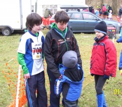 Left: Cian gives advice to Ruairi before the relay event at the Jan Kjellstorm festival of orienteering near London over the Easter week-end.
The Ajax Junior team were Dara, Oisin and Ruairi, and finished in 13th place.
The terrain was hilly but fast underfoot. Temperatures were icy at times with flurries of snow!
In total eleven Ajax member travelled to the event.
21:45 | Permalink | Comments (0)
Mar 17, 2013
Spring Cup Event - Bull Island - 24 March 2013
Event Location: The next Spring Cup competition will be held on 24 March 2013 on Bull Island , Dublin. (Grid Reference: O 234 370).
Event Directions and Parking: The event is signposted from the coast road (James Larkin Road). Use the causeway to reach Bull Island, and not the wooden bridge. Parking is on the the beach. Registration, start and finish are near the roundabout.
Registration: Please pre-register for the event by following the link: https://docs.google.com/forms/d/1KxgBjvw59lZINkaUk9WLjviJ... .
It will also be possible to register on-the-day at the event, but you are encouraged to pre-register before 9:00 PM on Sat 23rd March in order to reduce the workload for the event organisers. Everyone who pre-registers and competes will be included in a draw for Easter Eggs! The draw will take place after the last start.
Map: Maps are printed on water resistant material at a scale of 1:5,000 for all courses. The map shows the island in two sections laid out side-by-side on an A3 sheet. Contour interval is 2.5 meters. Power lines are not displayed and the magnetic grid lines run 45 degrees to the edge of the map. The Brown course uses a modified map with only contour and path detail displayed. Control descriptions for all courses will be available at registration and will also be printed on the map. The Yellow course has a taped route between two controls. This is indicated in the text version of the control descriptions, but not on the map.
Terrain: For anyone unfamiliar with Bull Island , the terrain consists of grass-covered sand dunes with many small paths, isolated trees and man-made features. Marshes are currently very wet but are crossable.
Timing: SportIdent (SI) timing will be used. SI cards are available for hire at event registration for €2. All participants must download their SI cards after orienteering, whether they complete the course or not. Otherwise the event organisers will not know whether participants have finished or not.
Start-times: 11:00 – 13:00.
Courses close: 15:00.
Event Officials:
Planner: Donal Wickham
Controller: Denis Reidy
Organiser: Aonghus O’Cleirigh
Course Details:
Brown - 11.3 k, 29 controls, (contours/paths only)
Blue - 8.6 k, 27 controls
Green - 6.6 k, 22 controls
Light Green - 4.0 k, 16 controls
Orange - 2.6 k, 12 controls
Yellow - 1.6 k, 12 controls
Entry Fees:
Adult: €8
Junior/Full-time Student: €5
Family: €20
Important: Bull Island is an EU designated Special Area of Conservation. Please do not cause damage or litter.
23:24 | Permalink | Comments (0)
Jan 30, 2013
Dublin-by-Night Killiney Hill Park
Round four of the 2013 Dublin-by-Night league takes place this Saturday evening, February 2nd, in Killiney Hill Park, Dublin. Starts are from dark until 7PM. The courses will close and control collection will start at 8PM sharp.
Please register here even if you are not certain you will go - it's easier to delete your entry from the computer than to type in your details at the event. Make sure to include your mobile phone and transport arrangements (e.g. car reg number) on the entry form, this information is for safety only. Online registration closes at approx 4PM on Saturday; after that time please register at the event when you arrive.
This event returns to the minimalist style of organisation used for Dublin-by-Night events in days of yore. This means:
- There will be no signposts to the event. Killiney Hill Park is a short walk from Killiney Dart station and various bus routes.
- There will be no loose control descriptions, print your own or use the ones that are printed on the front of the map.
- The start will be unmanned, please start yourselves at approx one minute intervals.
Long course: 3.7km, 140m climb, technical difficulty 5.
Short course: 1.8km, 55m climb, technical difficulty 3.
The area is a mix of open parkland and steep forested hills with a lot of complex rock and vegetation detail. Map scale 1:5,000, with 5m contour intervals. Note that ISSOM conventions are used which means that a solid black line is an uncrossable wall, not a path. The start of one small track near the obelisk at the top of Killiney Hill is marked with red/white tape. Due to the hilly nature of the park the courses are quite steep. Runnability is good but sometimes slippery, especially in the forest on the northern side of Killiney Hill.
All roads outside the park gates and the quarry area on the east of the map are out-of-bounds; you will be disqualified if you leave the park or approach the quarry.
We are using Sportident timing. Cards will be available to rent for €2 at the event. You must return to the registration car and download your SI card immediately after punching the finish. Please make sure your Sportident card registration is up-to-date. This event is for experienced orienteers only; beginners and novices should consider one of the many daytime events in the fixtures list. Under-16s are not allowed.
If you use a Garmin 305 GPS watch please ask for your watch to be downloaded alongside your SI card - I want to do an experiment to auto-publish your tracks to RouteGadget so that you don't have to upload them later. Garmin 305 only, not other Garmin models or other manufacturers.
Current Dublin-by-Night league standings after three of five rounds.
22:37 | Permalink | Comments (0)
Nov 05, 2012
Marlay Park - November 11th
Location. The next Ajax event will be held in Marlay Park on Sunday 11th November. A new map of the area surveyed by Laurence Quinn will be used. The map is drawn at 1:5000 scale and to ISSOM (Sprint Orienteering) standard. It is an open event. Everyone is welcome.
Parking is in the public car park off College Road (GR O150259). The event will be sign-posted from the entrance to the park. See here for more information.
Registration. Registration, start and finish are located near parking. SportIdent timing will be used. If you do not own one, a SportIdent card can be hired at registration for €2.
Start-times are between 11 am and 1 pm.Courses close at 2:30 pm.
Courses: There are three courses on offer:
Long – 5.5k
Medium – 3.5k
Short - 2.0k (Easy navigation)
Event Officials: Planner - Rory Wallace. Controller - Andrew Johnston. Organiser - Aonghus O'Cleirigh
Entry Fee: Senior €6. Junior/Student €4. Family €16.
20:36 | Permalink | Comments (0)
Sep 12, 2012
LOC 2012 - Entries close on Sun 16th Sept.
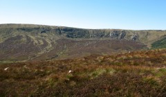
LOC 2012 - View across the upper Glenmacnass valley
19:55 | Permalink | Comments (0)
May 12, 2012
Irish Orienteering Championships 2012
Irish Orienteering Championships 2012
Ajax members competed strongly at the Irish Orienteering Championships in Kerry last week-end. All three days were held on open sand-dune terrain. In the relays Ajax won two of seven classes available, the only club to win more than one class. The club punched above its numerical weight!
Middle Distance (Day 1) - Castlegregory
Gold: M16 - Cathal O'Cleirigh, M50 - Aonghus O'Cleirigh.
Silver: M12- Dara O'Cleirigh, M60 - Denis Reidy.
Bronze: M10 - Oisin Wickham.
Classic Distance (Day 2) - Inch
Gold: M12 - Dara O'Cleirigh, M14 - Ruairi Long, W16 - Roisin Long, M16 - Cathal O'Cleirigh.
Silver: M10 - Oisin Wickham, W45s - Catherine King, M60 - Denis Reidy.
Relay (Day 3) - Maharees
Gold:
J36 class - Dara O'Cleirigh, Oisin Wickham, Ruairi Long,
H12 class - Cathal O'Cleirigh, Denis Reidy, Aonghus O'Cleirigh.
23:09 | Permalink | Comments (0)
Mar 18, 2012
Spring Cup Event 4 - Bull Island - 25 March 2012
Event Location: The next Spring Cup competition, organized by Ajax , will be held on 25 March 2012 on Bull Island , Dublin. The start/finish will be at the South end of the island (Grid Reference: O 220 354).
Event Directions and Parking: The event is signposted from the coast road (Clontarf Road). Use the wooden bridge to reach Bull Island, and not the causeway. Parking is on the the beach. Registration, start and finish are nearby.
Registration: In order to minimise manual data input on competition day please pre-enter for the event by following this link: http://www.formstack.com/forms/ajax-BullIsland . You pay the entry fee upon arrival to the event. It will also be possible to enter on-the-day at the event in the usual way, but you are encouraged to pre-enter if possible.
Map: The map has been partially updated, with newly formed dunes and paths added. Maps are printed on water resistant material at a scale of 1:5,000 for longer courses, and scales of 1:4,000 and 1:3,500 for Orange and Yellow courses. Contour interval is 2.5 meters. Power lines are not displayed and the magnetic grid lines run 45 degrees to the edge of the map. For longer courses the map shows the island in two sections laid out side-by-side on an A3 sheet. Shorter courses are printed on an A4 extract. The Brown course uses a modified map with only contour, marsh and path detail shown. Control descriptions for all courses will be available at registration and will also be printed on the map.
Terrain: For anyone unfamiliar with Bull Island , the terrain consists of grass-covered sand dunes with many small paths, isolated trees and man-made features. Marshes are crossable.
Timing: SportIdent (SI) timing will be used. SI cards are available for hire at event registration for €2. All participants must download their SI cards after orienteering, whether they complete the course or not. Otherwise the event organisers will not know whether participants have finished or not.
Start-times: 11:00 – 13:00.
Courses close: 15:00.
Note that Summer Time begins on Sunday 25 March. Clocks go forward by 1 hour.
Event Officials:
Planner: Mike Long
Controller: Donal Wickham
Organiser: Aonghus O’Cleirigh
Course and Map Details:
Brown (A3), 10.9 k, 70 m, 28 controls, 1:5000, (contours/marsh/paths only)
Blue (A3), 8.4 k, 50 m, 22 controls, 1:5000
Green (A3), 6.6 k, 40 m, 17 controls, 1:5000
Light Green (A3), 4.3 k, 30 m, 15 controls, 1:5000
Orange (A4), 2.6 k, 15 m, 16 controls, 1:4000
Yellow (A4), 1.8 k, 10 m, 11 controls, 1:3500
Entry Fees:
Adult: €8 (IOA club member), €10 (non-member).
Junior/Full-time Student: €5 (IOA club member), €7 (non-member).
Family: €20 (IOA club member), €25 (non-member).
Important: Bull Island is an EU designated Special Area of Conservation. Please do not cause damage or litter.
23:36 | Permalink | Comments (0)