
Leinster Orienteering Championships 2018
Ajax are proud organisers of the 2018 Leinster Orienteering Championships in the Vale of Clara & Ballinastraw, Rathdrum, County Wicklow on Sunday February 25th 2018.
About us
AJAX is an orienteering club based in Dublin, Ireland... More
IOA Policy
Ajax Orienteering Club implements the Irish Orienteering Association's anti-doping, anti-discrimination, child-protection and land-access policies, details of which are available on www.orienteering.ie
AJAX Child Safeguarding Statement (CSS)
AJAX Child Safeguarding Statement (CSS)
News
Ajax Committee 2023
Chairman:
John O'Donovan
Secretary:
Oisin Wall
Treasurer:
Mike Long
Mapping:
Paul
Children and Liaison:
Donal Wickham
Equipment:
John DeLacy
Webmaster:
Marcus Geoghegan
Did you know?
You can use RSS to keep up to date with changes to the website. Use the RSS link at the bottom of this column with your favourite RSS reader.
Contact Ajax
Our Photostream
We have set up a Flickr account so that club members can share their photos on line. It also allows photos to be displayed on this website.
Useful Links


Copyright on all material lies with Ajax Orienteering Club or the original copyright holders. Permission should be sought before use.
Feb 29, 2012
Leinster Orienteering Championships 2012
LOC 2012, organised by AJAX, takes place on 30 Sep 2012 on 'Carraig Na Seabhac' ('Rock of the Hawks'). The competition area was to have been used for the Irish Championships last year, but in the end could not because of breeding Peregrine falcons and Merlins.
The terrain is a mixture of open mountain and dense thickets, with a wealth of rock features. The area is generally quite runnable but in places vegetation underfoot impedes progress. The map was surveyed in 2010/11 by Pat Healy.
The competiton area is bounded to the east by the Military road, to the south by the Glenmacnass waterfall, to the west by the Barnacullian ridge, and to the North by Carrigshouk mountain.
An LOC competition website will be setup before long.
20:55 | Permalink | Comments (0)
Feb 01, 2012
Dublin-by-Night, Slade Valley Woods, Feb 4th
The penultimate event of the 2011/2012 Dublin-by-Night league takes place this Saturday, February 4th, in Slade Valley Woods, County Dublin.
Location: Slade Valley Woods is the Northern part of the old Saggart Woods orienteering map that was used for many years for Leinster league events. It was last used for an orienteering event for a night-O in February 2008.
Directions: Drive south from Saggart Village (near Citywest Business Park) and pick up the signs for Slade Valley Golf Club. The route will NOT BE SIGNPOSTED, please follow the golf club signs - the event is very close to the golf club entrance. There is an alternative route via the N81 Blessington road, but again this will not be signposted.
Grid Ref = O 022 242
Lat/Lon = 53.25895 (north), -6.46729 (west)
Lat/Lan = 53°15'32" (north), 6°28'2" (west)
Loc8 = NT2-08-KT7
Parking: please only park on one side of the road and only park downhill from the registration car. Car pooling is encouraged.
Map: 1:7,500 with 5m contours, bagged in polypockets, A4 portrait, minor updates January 2012.
 Terrain: Typical Irish plantation forestry. There has been extensive felling in the area although some pockets of nice forest remain. There is some bramble and a lot of paths/roads. Due to recent rain some parts of the area are very muddy, especially forest roads used by nearby stables. In horse-racing parlance, the going in some places is “heavy”.
Timing: Sportident electronic timing will be used. Please make sure your sportident card is properly registered - it makes things a lot easier for the organisers. If you do not have a Sportident card, they will be available for hire for €2 each and you will be required to leave a deposit.
The start will not be manned, please organise yourselves and leave a reasonable time gap after the previous starter. The start and finish are in the same place.
Start Times & Course Closure: starts are from dark to 7PM. Control collection will commence at 8:15PM. You MUST report back to the download car even if you retire and do not finish the course. Failure to download might lead to an unnecessary search and you will be unwelcome at future Ajax Orienteering events.
Batteries: not included.
Moon Phase: waxing gibbous, high in the eastern sky.
Safety & Cancellation: This orienteering event does not visit open mountainside. However it is February and inclement weather should be expected - a rain jacket/cagoule might be mandatory. All competitors must carry a whistle. If you get hopelessly lost walk WEST along the forest roads until you reach the start/finish. If the weather on the day is severe there is always the possibility of the event being cancelled - if you are in doubt please check this website before travelling.
Under-16s: for insurance reasons under-16s are not permitted.
Novices: this event is not suitable for novice orienteers, instead you should plan on going to the orienteering event in Hellfire Wood on the morning of Sunday 5th, see the Setanta website for details.
Entry Form: please download the entry form and fill it in before travelling.
Control Descriptions: these will be printed on the front of the maps in IOF pictorial format. Loose control descriptions will NOT be available at the event - they are on the entry form (see link above). You can print them yourself or you can use the descriptions on the map. There will be no little bits of paper at the event!
Results: Live results will be available online - bookmark this page on your mobile phone so that you can see the results as they come in.
Long: 3.6km, 120m, 17 controls : experienced orienteers only
Short: 2km, 70m, 9 controls : experienced orienteers only
Planner: Marcus Geoghegan, Ajax
08:39 | Permalink | Comments (0)
Nov 14, 2011
LEINSTER AUTUMN SERIES #5
Event Location: Autumn Series event number 5, organized by Ajax, will be held on 20-Nov-2011 on Glendoo Ridge West, Co. Dublin. (Grid Reference: O 131 198).
Event Directions and Parking: The event is signposted from Killakee. Travel approx. 2.5 km from Killakee on the road towards Glencree. Parking is off-road on tracks, and is close to the event start and finish.
Map: The area was previously used for the IOC relays this year. Maps are pre-marked and printed at a scale of 1:7,500 on water resistant material. Contour interval is 5 meters. Control descriptions for all courses will be available at registration and are also printed on the map. The Brown course has a map exchange with each course printed on opposite sides of the same sheet.
Terrain: The terrain consists of open bog-land with numerous peat cuttings, and is moderately hilly. The ground is quite runnable, and there are some paths. There are a number of water filled holes not marked on the map. Care should be taken, especially by children, when running near water filled holes. No course is buggy friendly.
Start-times: 11:00 am – 1:00 pm.
Courses close: 3:00 pm.
Timing: SportIdent (SI) timing will be used. SI cards are available for hire (€2) at event registration. You must report to the finish officials even if you decide not to complete your course. If you fail to do this, the organizers have no way of knowing where you are. At the finish, please make sure you download your SI card
Event officials:
Controller: Denis Reidy.
Organizer: Donal Wickham
Planner: Aonghus O’Cleirigh
Course Details:
Brown - 10.2 k, 255 m, 29 controls, (map exchange)
Blue - 7.4 k, 170 m, 24 controls,
Green - 5.1 k, 105 m, 19 controls,
Light Green – 3.3 k, 100 m, 19 controls,
Orange - 2.5 k, 75 m, 12 controls,
Yellow - 1.6 k, 20 m, 10 controls,
Entry Fees:
Club Members: Adult - 8 Euros, Junior / Full-time Student - 5 Euros, Family - 20 Euros.
Non-Club Members: 10 Euros.
Out-of-Bounds: For safety reasons the public road to the South-West is out-of-bounds.
Routegadget of the 2011 Irish Relay Orienteering Championships
Important: Please do not cause damage or litter.
16:40 | Permalink | Comments (0)
Mar 27, 2011
Irish Championships
Nothing to see here, the whole club is focussed on organising the 2011 Irish Orienteering Championships on the May bank holiday weekend.
Are you looking for the IOC2011 Satnav PoI file?
20:31 | Permalink | Comments (0)
Nov 17, 2010
Vale of Clara Nature Reserve
Leinster Autumn Series 2010 #4
Sunday November 21st 2010
Vale of Clara Nature Reserve, County Wicklow
Grid Reference T 185 923
Loc8 Code: SNQ-79-CX9
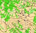
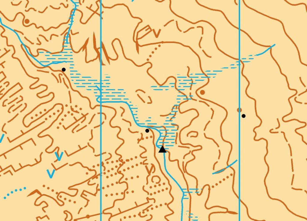
 The Vale of Clara Nature Reserve is the area formerly known to orienteers as Cronybyrne. The new 2009 map is a part of the larger Cronybyrne/Ballinastraw area initially surveyed in the early 1980s, incorporated into the Claravale map for the 1987 World Military Championships (CISM) and used for the 1993 Leinster championships as well as numerous Leinster League events.
Organised by: Ajax Orienteering Club, ajax.orienteering.ie
Online Check-In: This orienteering event is using an online check-in system - please use it as it will make things much easier for the hard-pressed organisers if they know in advance that you are coming to the event. However you will also be welcome even if you just turn up and enter on the day. The online check-in system will close at 10PM on Saturday November 20th. You can see who has already checked-in here.
Newcomers: This orienteering event is suitable for beginners and experienced orienteers alike. Bring clothing that is suitable for a day out in the woods, e.g. raincoat, boots/old runners and clothes that you don't mind getting dirty. It is best to arrive by about 11AM.
Groups: if you plan to bring a group to the event please email ajax@orienteering.ie as soon as possible so that we will have enough pre-printed maps.
Directions: There will be signposts from Laragh, County Wicklow. In Laragh turn south at Lynham's pub onto the Rathdrum road; after about 400m you will reach a junction where a small road goes straight ahead and the main road veers right across a narrow stone bridge. Take the small road straight ahead and drive for about 6.5km to the event. Parking will be in a Coillte forest north of the nature reserve - please follow the marshals' parking directions. For orienteers living near the N11/M11 there is a viable route via exit 15 for Ashford and onwards to Garryduff crossroads. This route will not be signposted.
Map: 1:10,000 with 5m contours, printed on waterproof paper, A4 landscape, updated Summer 2009 by Marcus Geoghegan, minor revisions Autumn 2010.
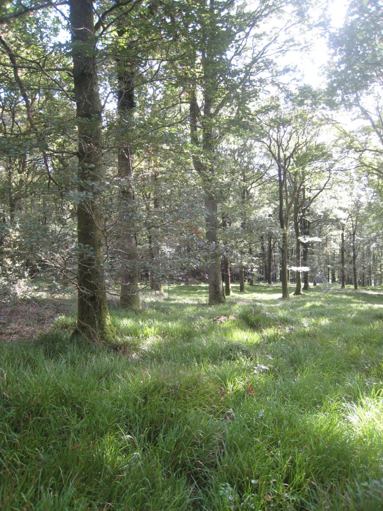
Terrain: Mature Oak woodland with occasional Scots Pine and Birch. Visibility is nearly always good but runnability varies - underfoot you will find sedge grass, Fraochán bushes (bilberry) and bracken fern. In some areas runnability is impeded by high bracken - these areas have been mapped with widely spaced green hatching. There are a few small areas of bramble which have been mapped with closely spaced hatching. During the 1990s a long-term project was started to return the Reserve to native woodland so most non-native trees (plantation conifer & hemlock) have been removed. Here are some photos of the terrain. The Irish Farmer's Journal has written a good article about the area's wonderful flora and fauna.
Sportident electronic timing will be used. Please make sure your sportident card is properly registered - it makes things a lot easier for the organisers. If you do not have a Sportident card, they will be available for hire for €2 each and you will be required to leave a deposit.
Registration will be at the car park entrance.
Start Times & Course Closure: starts are between 11AM and 1PM. Courses close at 3PM promptly and the controls will be collected at this time, so please make sure that you have reported to the download tent before 3PM.
Start: Approx 15 minutes walk from the parking/registration. The first 250m of this walk is along the road you travel to the event on. The remainder of the walk is along a quieter road that leads down to Clara bridge. Please accompany juniors.
Finish: Adjacent to the parking and registration area.
Download: when you return to the car park you MUST download your sportident card - the place to do this will be clearly signposted. You must download even if you retire and do not finish the course. Failure to download might lead to an unnecessary search and you will be unwelcome at future Ajax Orienteering events.
Clothing transfer: There will be no clothing transfer system in operation.
Safety & Cancellation: This orienteering event does not visit open mountainside. However it is November and inclement weather should be expected - a rain jacket/cagoule might be mandatory. All competitors must carry a whistle. If you get hopelessly lost walk north (usually uphill) along the forest roads until you reach the tarmac road where the car parking is located. The brown course crosses Cronybyrne Brook - please use the bridges and do not attempt to wade across. If the weather on the day is severe there is always the possibility of the event being cancelled - if you are in doubt please check the Ajax website (ajax.orienteering.ie) before travelling. The quarry in the centre of the map is dangerous and should not be approached from above; however no course is planned in the vicinity of the quarry. Horses occasionally use the Reserve - please watch out for them as a startled horse can be dangerous.
Control Descriptions will be printed on the front of the maps in IOF pictorial format, except for the yellow course which will have text descriptions. CONTROL DESCRIPTIONS WILL NOT BE AVAILABLE AT THE EVENT. You can download the control descriptions and print them yourself, or you can use the descriptions on the map. There will be no little bits of paper at the event!
Results:  weather permitting, live results will be displayed on a computer screen beside registration. Live results will also be available online - bookmark this page on your mobile phone so that you can see the results as they come in. Full results, including splitsbrowser, routegadget and winsplits will be available on www.orienteering.ie on the evening of the event.
Leinster Autumn Series: this event is the fourth of five in the 2010 Leinster Autumn Series - you can see the automatically updated current league standings in the results section of www.orienteering.ie. Best 3 of 5 to count.
Refreshments: tea/coffee/biscuits will be available near the registration.
Course: Length, Climb, #Controls : Suitability
Brown: 7.5km, 325m, 26 : very experienced orienteers only
Blue: 5.8km, 245m, 19 : experienced orienteers only
Green: 4.7km, 170m, 16 : experienced orienteers only
Light Green: 3.6km, 120m, 13 : improvers
Orange: 2.3km, 100m, 12 : "off the paths"
Yellow: 2.2km, 90m, 12 : novices/young juniors/families
Buggies: the yellow course is not suitable for buggies, however there are nice buggy-friendly marked trails in the nature reserve.
Acknowledgements: Ajax thanks the National Parks and Wildlife Service for permission to use the reserve and Coillte for permission to park in Glenwood.
Planner : Marcus Geoghegan, Ajax
Controller: Peter Kernan, Ajax
Assistant Controller: Mike Long, Ajax
Organiser: Denis Reidy, Ajax
Orienteering is an adventure sport, all competitors take part at their own risk.
16:05 Posted in Event Notice | Permalink | Comments (0) | Tags: vale of clara nature reserve
Oct 13, 2010
Marlay Park non-league orienteering event, October 17th
Ajax are running a non-league orienteering event in Marlay Park, Rathfarnham, South Dublin on Sunday October 17th, 2010. Start times are between 11AM and 1PM. Courses close at 3PM. There will be three courses: Long, Medium and Short. The event is suitable for beginners and experienced orienteers alike. Beginners do not need to bring anything other than a pair of runners and a rain jacket. You do not need to pre-enter, just turn up and enter at the event. It is best to arrive at about 11AM.
Motorists should enter the park via College Road which runs parallel to the M50 at the park's southern end.
Many buses go to the northern end of the park - go to the route planner on dublinbus.ie and select "Grange Road, Three Rock Hockey Club, Stop 2980" as your destination, and then walk south through the park to the event start in the southern carpark.
Sportident electronic punching will be used. If you have an SI card please make sure it is properly registered in the database.
 Maps are pre-printed with control descriptions on the back. If you want loose control descriptions then download them here, they will not be available at the event.
Bookmark http://orienteering.ie/live/view.php?marlay to get live results from about 10:30 onwards.
Planner: Denis Reidy, Ajax
More information about Marlay Park is available on wikipedia.
09:39 Posted in Event Notice | Permalink | Comments (0) | Tags: marlay park
Sep 19, 2010
Ajax go to Junior Home International
..............by Mike Long
I had the pleasure of attending my first JHI over the weekend of 10-12 September, based around Perth and Stirling in Scotland. On paper the Irish team looked strong and so it was proven in practice with a comfortable overall win over Wales to win the Judith Wingham trophy for the first time in many years. Can anybody actually remember when we last won?
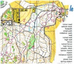
The JHI coincided with the World Park Tour. Our first port of call therefore was Scone Castle on the Friday afternoon where we were able to run over the courses earlier used by the elites in the qualification race for Saturday’s final. A sample from the map is shown below. Personally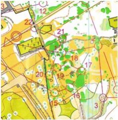 I found the dark green detail confusing but it did not seem to bother the Juniors. As Greg pointed out to me “you have to run at the same speed as which you can orienteer”.
There was also a maze-O (south end of map) done by the Juniors without a map! The winner was Alex who got to the centre via the exit. Nobody had spelled out the rules! It was a good start and got everyone’s head on the job at hand.
Unusually the relay was held on Saturday (so that all could go to watch the elites in Perth town centre later). Several of the Juniors were familiar with the map of Kinnoull Hill, as it had been used at the 2009 Scottish 6 day. The map (part of if reproduced below) is characterised by steep runnable woodland with many paths. In fact most of the juniors said they had to ignore the paths, which they found confusing and focus on the contours.
 Overall we did very well. The boys were 8th, 11th and 12th and the girls were 7th, 11th and 13th. At the end of the day England, on 54 points, had a 4 point lead over Scotland. We were on 24 points, 8 ahead of Wales.
Then it was off to Perth where we had the pleasure of watching Niamh O’ Boyle and Nick Simmonin compete with several of the best elites in the world literally in Perth town centre much to the bemusement of the local shoppers. Both placed in the top 10 behind the very impressive Helena Jansson of Sweden and Østein Kvaal Østerbø of Norway.
Then there was the ceilí. I will let someone else tell the story here!
On to Devilla Forest for the long distance individual races on Sunday. Here the forest was pretty flat with much fewer paths and subtle (to me at least!) contour detail, see below. The only issue here was the “white” area were very rough with waist (except for Colm Moran) high heather and a net work of old drains. Keeping a bearing was very difficult. The M18’s had a very long leg through the middle of the map and several of the lads choose to run the path to the east (some 3 km) which turned out to be as quick.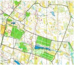
Again the performances were very good our best runner in each class were Caoimhe (7th), Niamh (7th), Áine (6th), Jonathan (4th), Jack (6th) and Séan (5th): strong across the board.
We ended up on 61 points well ahead of Wales 45. England, on 135 points, also had a very comfortable 16 point margin over Scotland. Full detailed results can be found on www.rstrain.ndtilda.co.uk/results 10/jhi/
My overall view of the results was that although we had no individual medal winner we performed strongly with strength in depth in most of the classes and we were certainly not hovering around the bottom.
My 3 personal running highlights of the weekend me were:
 • Cliona Mc Cullough’s first back in the relay despite leaving both her shoes in a marsh in the forest!
• The sight of the four M16’s finishing the relay more or less together
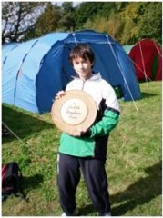
• Jonathan Quinn’s excellent 4th place in the M14 long distance, 13 seconds off a medal (The picture below shows Jonathon with the winning team trophy. Jonathan was also named the best Irish performer).
The entire Irish crew are shown below:
Back row left to right: Cilín, Megan, Colm, Laura, Cliona, Jack, Séan, Mark, Alex, Jill, Conor, Áine, Andrea, Niamh, and Lawrence
Front row: Cathal, Caoimhe, Róisín, Jonathan, Deirdre, Peter and Donal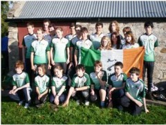
The other competition of the weekend was on the various roads between Edinburgh, Perth and Stirling. The drivers Ruth, Kathryn and I were forced into various, often strange, route choices by our intrepid navigators. Lawrence and Colm can fill in the details!
It was the last JHI for Colm, Conor, Laura and Séan. They will be clearly missed but a first for Cathal, Donal, Peter, Róisín and Megan. One would have to conclude all is well in Irish Junior Orienteering. It was also clear to me that none of the above would have happened without the dedication and hard work over the past number of years by Ruth and Greg. Roll on 2011!
20:41 | Permalink | Comments (0)