
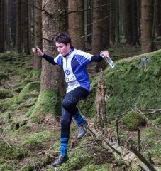
Leinster Orienteering Championships 2018
Ajax are proud organisers of the 2018 Leinster Orienteering Championships in the Vale of Clara & Ballinastraw, Rathdrum, County Wicklow on Sunday February 25th 2018.
About us
AJAX is an orienteering club based in Dublin, Ireland... More
IOA Policy
Ajax Orienteering Club implements the Irish Orienteering Association's anti-doping, anti-discrimination, child-protection and land-access policies, details of which are available on www.orienteering.ie
AJAX Child Safeguarding Statement (CSS)
AJAX Child Safeguarding Statement (CSS)
News
Ajax Committee 2023
Chairman:
John O'Donovan
Secretary:
Oisin Wall
Treasurer:
Mike Long
Mapping:
Paul
Children and Liaison:
Donal Wickham
Equipment:
John DeLacy
Webmaster:
Marcus Geoghegan
Did you know?
You can use RSS to keep up to date with changes to the website. Use the RSS link at the bottom of this column with your favourite RSS reader.
Contact Ajax
Our Photostream
We have set up a Flickr account so that club members can share their photos on line. It also allows photos to be displayed on this website.
Useful Links


Copyright on all material lies with Ajax Orienteering Club or the original copyright holders. Permission should be sought before use.
Mar 16, 2015
Bull Island - Leinster League - Sunday 22-March-2015
Event Location: The next Leinster League event will be held on 22 March 2015 on Bull Island, Dublin. (Grid Reference: O 234 370).
Event Directions and Parking: The event is signposted from the coast road (James Larkin Road). Use the causeway to reach Bull Island, and not the wooden bridge. Parking, registration, start and finish are near the roundabout.
Map: Maps are printed on water resistant material at a scale of 1:5,000 for all courses. The map shows the island in two sections laid out side-by-side on an A3 sheet. Contour interval is 2.5 meters. Power lines are not displayed and the magnetic grid lines run 45 degrees to the edge of the map. The Brown course uses a modified map with only contour, building and marsh detail displayed. Control descriptions for all courses will be available at registration and will also be printed on the map. The Yellow course has a taped route on two legs. This is shown in the text version of the control descriptions, but not on the map.
Terrain: The terrain consists of grass-covered sand dunes with many small paths, isolated trees and man-made features. Marshes are currently wet but are crossable.
Timing: SportIdent (SI) timing will be used. SI cards are available for hire at event registration for €2. You must download your SI card after orienteering, whether you complete the course or not. Otherwise the event organisers will not know if you have finished.
Start-times: 11:00 – 13:00.
Courses close: 15:00.
Registration and Entry Fees: Enter at the event. If you are new to orienteering please let the organisers know and they will show you what to do.
Adult: €8
Junior/Full-time Student: €5
Family: €20
Event Officials:
Controller: Denis Reidy
Organiser: Mike Long
Planner: Aonghus O’Cleirigh
Course Details:
Brown – 9.1 k, 30 controls, (contours/marsh/buildings only)
Blue - 8.3 k, 29 controls
Green – 5.4 k, 26 controls
Light Green – 3.1 k, 19 controls
Red – 3.1 k, 19 controls
Orange - 2.2 k, 16 controls
Yellow - 1.4 k, 12 controls
Important: Bull Island is an EU designated Special Area of Conservation. Please do not cause damage or litter. Thanks to DCC for granting permission to hold the event.
11:27 | Permalink | Comments (0)
Feb 04, 2015
Dublin by Night event in Glendoo
Ajax is pleased to host the next Dublin by Night event of 2015 at Glendoo Ridge West this coming Saturday (Feb. 7th.). Yes, I know that this area is actually in Wicklow, but the idea behind the Dublin by Night series (according to Martin - who should know), is that it should take place in areas from which you can see the lights of Dublin. I'm pretty sure that if you look north during the event on Saturday, then you should see the faint glow of the lights of Dublin in the sky... Nuff said?
The weather forecast looks favourable at the moment with slightly warmer conditions and a mostly dry night predicted.
Thanks: Glendoo Ridge West is located in the Wicklow Mountains National Park and we would like to express our thanks to the Wicklow Mountains National Park, the Department of the Environment, Heritage and Local Government for permission to use the area for the event.
Date: Saturday, Feb. 7th, 2015.
Time: Starts from 18:00 to 19:00.
Courses Close: 20:30.
Location: Glendoo Ridge West.
Grid Ref: O 131 196.
Organised by: Ajax Orienteering and Hill-running Club.
Guilty party: Paul
Contact:
Email:
The short version: No loose descriptions - download your own (here). Experienced orienteers only on the long. You must carry a jacket, compass and whistle. No under 16s. Scale is 1:5000/5m. Road is out of bounds. Finishers after 20:30 will be disq'd. No signage except at entrance to event. Online registration is here. Online registration closes at 22:00 on Friday Feb. 6th.
Safety: This is a night event on rough open mountain, in winter, and all competitors must carry a jacket, whistle and compass - no exceptions. Given that the event is in early February it’s almost guaranteed that the weather will be cold - possibly bitterly cold and possibly very wet.
The area is exposed and littered with potential hazards so please come prepared and exercise caution at all times.
In general, from most areas on the map, heading west will get you to a road or track fairly quickly.
We reserve the right to cancel or curtail the event in the event of poor weather. Check the forums on Orienteering.ie and this webpage for any changes on the day of the event.
Out of Bounds: The public road that forms the southern boundary of the map is out of bounds to all competitors except in the event of an emergency.
Groups: if you plan to bring a group to the event please email as soon as possible so that we can ensure that we have enough pre-printed maps. Likewise, if you are not a usual attendee at the Dublin By Night events please let us know you are coming. Registration is now open here. Online registration closes at 22:00 on Friday Feb. 6th.
Entry Fees: Adult €8, Student €5
Directions: The only signage for the event will be from the turn-off on the R115. There will be an orienteering banner here rather than an orienteering flag. If anyone needs directions please email me giving an indication of where you are travelling from.
For any of our hill-running friends attending, the entrance to the parking is opposite the track where the hill-race up Kippure starts.
Sportident electronic timing will be used. Sportident cards will be available for hire for €2 each together with a €20 deposit.
Parking: Parking is on a large flat area a short distance off the R115. 200 metres after turning off the main road you reach a turn on the right. The way on will be blocked with tape. Turn right and about 100 metres later you will come to a wide flat area where you can park. Please park considerately so there is room for everyone. Please be careful as the area is unlit and there will be competitors moving about the parking area.
Start, Finish & Registration: Adjacent to parking.
Start Times & Course Closure: starts are between 18:00 and 19:00. Courses close at 20:30 and control collection will begin at this time. Competitors who do not report to the finish by 20:30 will be disqualified regardless of whether they have finished or not.
Download: When you finish you MUST download your sportident card even if you retire and do not finish the course.
Courses: There are two courses as follows:
Long: 4.4 km, 120 m climb with 26 controls.
Short: 1.6 km, 20 m climb with 12 controls.
Neither course is designed with beginners/novices in mind and only experienced orienteers will be permitted on the long course. Absolutely no-one under the age of 16 is permitted to take part, regardless of whether they are accompanied by an adult or not.
I have tried to plan the courses so that they are both fun and challenging. Let me know whether I’ve succeeded or not.
Terrain: The area is open mountainside consisting mostly of worked bog. There are extensive drainage ditches, turf cuttings and other features of peat extraction. A few vehicle tracks cross the area. Going underfoot varies from fast and runnable to heavy wet marsh and deeper heather. The ground is very uneven in most places and as this is a night event competitors should take particular care. Much of the area covered by the courses is relatively flat but the long course ventures onto the steeper part of the map.
Map: The map is A4, at a scale of 1:5000 with 5 m contours and is printed on waterproof paper. There is no legend on the map.
A black X represents a small ruined hut/shelter and there are several of these on the map. These are very small (about 6’ x 6’) and may be partially buried.
North lines are printed in black and are aligned with the long edge of the paper. There are a few boulders on the map. Although these appear on the enlarged map as a largish dot they are small (< 1m high) and generally at least partially covered by heather making them difficult to spot. Paths/tracks marked as indistinct also require care to locate.
Features marked as ditches often have deeply cut sides not represented on the map by bank symbols. Parallel banks separated by distances too small for separate bank symbols are generally represented by the gully symbol.
Control Descriptions: are in IOF format on the front of the map. Loose descriptions will NOT be available on the night but you can download them (here). Apologies for the poor quality but it appears Purple Pen cannot export descriptions in PDF format!
Turf banks and cuttings are indicated in the control descriptions by the earth-bank symbol.
Results: Full results, including splitsbrowser and routegadget will be available on orienteering.ie as soon as possible after the event.
Refreshments: We hope to provide some light refreshments for those hardy or foolish enough to stand around after their run!
Orienteering is an adventure sport, all competitors take part at their own risk.
23:39 | Permalink | Comments (0)
Nov 03, 2014
Carraig Na Seabhac - 9th November 2014
Event Location: The next Autumn League event (No. 4) will be on 9th November 2014 at Carraig Na Seabhac, Old Military Road, Co. Wicklow (Grid Reference: O 101 052).
Event Directions and Parking: The event will be signposted from the Sally Gap. Parking is on a forest track. Please car-share if possible as there is a limited amount of parking.
Registration: Please help us and register for the event online by opening the following link: Register online here. Online registration will close on Saturday night, 8th November at 20:00. It will also be possible to register on-the-day at the event, but if you register online it will reduce the workload for the event organisers.
Map: The map was surveyed in 2010-2011 by Pat Healy and partially updated in 2012 and 2014. The area was last used for the Leinster Championships in 2012. Maps will be printed on A3 size water resistant paper at a scale of 1:10,000. Contour interval is 5 meters. Control descriptions for all courses will be available at registration. Descriptions will also be printed on the map. Generally boulders less than 2m in height are marked on the map with the small boulder symbol. The large boulder symbol is used for boulders larger than 2m in height. The rock pillar symbol (black area symbol) is used for very large boulders. In areas of pervasive rock detail boulders which seem small in relation to neighbouring boulders are not generally mapped. Crags are mapped both with, and without tags. The dark green screen (fight) is used to mark pine thickets and young plantation. The semi-open screen is used to map scattered trees. Lone trees are marked with a green dot symbol.
Terrain: The area lies in the upper Glenmacnass river valley. One side of the valley is forested with thickets of young pine and scattered pine trees; the other is open hillside. There is considerable rock feature throughout. The valley is divided by a stream (the upper section of the Glenmacnass River) and is crossable by foot. The terrain underfoot varies from rough heather to grass. There are some paths in the wooded part of the competition area, but no paths in the open hillside. The valley sides are moderately steep.
Timing: SportIdent (SI) timing will be used. SI cards are available for hire at event registration for €2. Participants must download their SI cards after orienteering, whether they complete the course or not. Otherwise the event organisers will not know if you have finished.
Start and Finish: The start for all courses is approximately 600m -1000m from the Parking Area. Access to the Start is along a public road. Please take care when walking along or crossing this road. The route to the Start passes the Finish. The Finish for all courses is 300m – 700m from the parking area.
Competitor Safety: Because of the nature of the terrainwhistles must be carried by all competitors regardless of the weather. This rule will be strictly enforced with checks at the Start. In the event of bad weather the event organisers may enforce a requirement to carry suitable windproof/waterproof clothing. Whistles will be on sale the Assembly area. Full leg covering is required for all courses.
Start-times: 11:00 – 13:00.
Courses close: 14:30
Event Officials:
Planner: Aonghus O’Cleirigh
Controller: Marcus Geoghegan
Organiser: Donal Wickham
Course Details:
Brown – 9.0k, 275m
Blue – 7.3k, 215m
Green – 4.8k, 155m
Light Green – 3.2k, 135m
Red – 3.6k, 135m
Orange – 2.5k, 120m
Yellow – 2.0k, 95m
The yellow course is not buggy friendly. A forest ride used by the short courses is indistinct in places, and is marked by red and white tape. The Yellow course has one leg which is marked by red and white tape. The Brown, Blue and Green courses cross the Glenmacnass River.
Entry Fees:
Adult: €8
Junior/Full-time student/Unwaged/ OAP: €5
Family: €20
20:23 | Permalink | Comments (0)
Sep 27, 2014
"Come and Try it" Orienteering - Marlay Park 05-Oct-2014
Ajax will organise a "Come and Try It" orienteering event in Marlay Park on Sunday 5th October.
Start times are from 11:00 am to 1:00 pm. Courses close at 3:00 pm.
Three course options are available:
Short - 2.0 km (suitable for beginners and is buggy friendly)
Adventure - 4.4 km (suitable for physically fit adults new to orienteering)
Long - 5.5 km
The event is signposted from the College Road entrance (beside the M50). Parking, start and finish are in the lower car-park. If you are a beginner let the event organiser know and you will be shown what to do.
Entry fee: Adult - €8, Junior/Student/Unwaged/OAP - €5, Family - €20.
The map scale is 1:5000. The map is waterproof and control descriptions are printed on the front of the map.
SportIdent timing will be used. SportIdent cards can be rented for €2.
Please register online to save time or register at the event. Register online here. Online registration closes at 8:00 pm on Saturday 4th October.
For safety, after orienteering always report to the Finish team. You need to do this whether you complete your course or not. Otherwise the event organiser will not know where you are!
22:12 | Permalink | Comments (0)
Sep 15, 2014
Slievethoul Mountain Bike Orienteering, September 20th
 The 3rd event in the 2014 Leinster Mountain Bike Orienteering series is being organised by Ajax in Slievethoul on Saturday September 20th. Slievethoul is the southern part of the old Saggart orienteering map. It's been updated to add the new bike tracks - the vegetation mapping is very out-of-date but the trails are accurate. The terrain is typical plantation forest criss-crossed by a network of forest roads and MTB trails.
The navigation will not be difficult; the control points must be taken in sequence and it's all about choosing the fastest way to get to the next point.
Travel Directions: the event will not be signposted, but it's easy to find. Go to Saggart village in South Dublin and follow the signs for Slade Valley Golf Club. The event will be about 250 metres further along the road from the entrance to the golf club. Here's a travel map
Start times any time between 11:00 and 12:00. The courses will close at 13:30.
Entry fees: Adult €10, Student/Junior/over-65 €7. SportIdent electronic timing, SI cards can be hired for €2. There will be 2 courses, Long and Short.
Map scale 1:7,500 (1cm = 75 metres), paper size A4.
There is no need to pre-enter, just turn up in good time to be able to start between 11 and 12.
You must wear a helmet and you must respect other forest users. You do not have right of way. If you see horses you must stop until they have passed. Be aware that bikes will be travelling in both directions on the MTB trails. All tarmac roads are out-of-bounds - stay in the forest.
See you on Saturday.
22:39 | Permalink | Comments (0)
Jul 23, 2014
Marlay Park, July 29th 2014
After a short pause to catch its breath, the Leinster Orienteering Dublin summer league continues this Tuesday evening, July 29th, in Marlay Park. Starts are from 6PM until 7PM. Courses will close and control collection will start at 8PM. Watch out for stragglers from last week's Longitude music festival.
 Please register here (it's quicker than registering at the event)
This orienteering event is suitable for all ages and abilities; families with young children are welcome. If you are bringing a large group (e.g. scouts, school) please email ajax@orienteering.ie so that we can print enough maps for you.
The event will be signposted on College road; this is the southern entrance to the park beside the M50, it’s not the entrance near the house and gardens. See the Irish Orienteering fixtures webpage for travel details.
Marlay park is a typical Dublin urban park with a mix of forested areas and open playing fields. There is a lakelands area and a network of woodland trails. Marlay House and gardens are at the northern end of the map. The map scale is 1:5,000, with 5m contour intervals.
Control descriptions are printed on the front of the map. There will be no loose control descriptions at the event. Maps are printed on hydrophyllic paper in polypockets.
Long Course: 4.5km
Short Course: 2km
The short course is suitable for buggies and families. The long course is for runners.
We are using Sportident electronic timing. Sportident cards will be available to rent for €2 at the event. Make sure to return to the registration area and download your Sportident card immediately after finishing. If you own an SI card please make sure your Sportident card registration is up-to-date.
11:28 | Permalink | Comments (0)
May 06, 2014
Irish Orienteering Championships 2014
 IOC2014 - what a contrast in terrain and conditions! The sprint competition was organised in the manicured grounds of Maynooth University. The Middle Distance and Classic events were held in complex peat terrain at an altitude of 700m in clouds and mist. Visibility was as low as 20m at times. The Relay race was organised in mature forest and ‘fast’ open mountain. The combination of conditions made the Classic distance race probably the most challenging Irish Championships race ever held.
It was a triumph just to complete the course – most competitors did not!
 Ajax prize winners:
Sprint (Day 1) – Maynooth University
First: M10 Emmet O'Cleirigh, M12 Oisin Wickham, W18 Roisin Long, M50 Aonghus O'Cleirigh
Third: M14 Dara O'Cleirigh, W45 Catherine King, M50 Marcus Geoghegan
Middle Distance (Day 2) - Camaderry
First: M10 Emmet O'Cleirigh, W45S Catherine King
Second: M12 Oisin Wickham, M50 Aonghus O'Cleirigh
Third: W45S Cathleen Morrison
Classic Distance (Day 3) - Lough Firrib / Oakwood
First: M12 Oisin Wickham, W18 Roisin Long
Third: M10 Emmet O'Cleirigh, W45S Catherine King
Relay (Day 4) - Glenreemore Valley
First: H12 category - Roisin Long, Aonghus O'Cleirigh,
Third: J48 category - Oisin Wickham, Dara O'Cleirigh, Ruairi Long
22:14 | Permalink | Comments (0)