
Leinster Orienteering Championships 2018
Ajax are proud organisers of the 2018 Leinster Orienteering Championships in the Vale of Clara & Ballinastraw, Rathdrum, County Wicklow on Sunday February 25th 2018.
About us
AJAX is an orienteering club based in Dublin, Ireland... More
IOA Policy
Ajax Orienteering Club implements the Irish Orienteering Association's anti-doping, anti-discrimination, child-protection and land-access policies, details of which are available on www.orienteering.ie
AJAX Child Safeguarding Statement (CSS)
AJAX Child Safeguarding Statement (CSS)
News
Ajax Committee 2023
Chairman:
John O'Donovan
Secretary:
Oisin Wall
Treasurer:
Mike Long
Mapping:
Paul
Children and Liaison:
Donal Wickham
Equipment:
John DeLacy
Webmaster:
Marcus Geoghegan
Did you know?
You can use RSS to keep up to date with changes to the website. Use the RSS link at the bottom of this column with your favourite RSS reader.
Contact Ajax
Our Photostream
We have set up a Flickr account so that club members can share their photos on line. It also allows photos to be displayed on this website.
Useful Links


Copyright on all material lies with Ajax Orienteering Club or the original copyright holders. Permission should be sought before use.
Jan 08, 2018
2018 Leinster Orienteering Championships
Ajax are hosting the 2018 Leinster Orienteering Championships.
12:15 | Permalink | Comments (0)
Nov 05, 2017
Featherbeds Leinster League Nov 5th 2017
 Results have been published.
The 10th Leinster League event of the 2017 season is on November 5th 2017 in the Featherbeds/Glendoo area, County Dublin. (Grid Reference: O 131 196).
Event Directions and Parking: The event is signposted from the R115 (Military Road), the road from Dublin to the Sally Gap. The road passes through the competition area, which is situated on the Dublin side of upper Glencree valley. Parking, registration, start and finish are adjacent to the R115.
Competition Area: The competition area comprises part of the Glendoo map north of the R115 and part of Featherbeds area south of the R115. Some small updates have been made to the map since it was last used in 2015. The area consists of gently sloping open hillside with detailed turf cuttings and some paths. There are many water holes, some of which are not mapped. Runnability varies from medium to very slow. Here's a RouteGadget of the previous Leinster League event on this map.
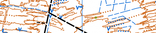
 Map: The map is printed on A4 water resistant paper at a scale of 1:7,500 for all courses. Contour interval is 5 meters. The map is aligned to magnetic North.
Beginners: This event is suitable for people of all ages who are new to orienteering. Enter at the event on the day - you do not need to register beforehand. If you are new to orienteering please let the organisers know and they will show you what to do. Unfortunately, due to the nature of the terrain, this event is not buggy friendly.
Fees:
Adult: €8
Junior/Full-time Student/OAP/Concession: €5
Family: €20
There will be a €2 surcharge for any participant who is not already a member of an orienteering club. The surcharge will be waived if the participant registers with Ajax Orienteers at the event. (Membership is free for the first year).
Groups:
If you plan to bring a large group please email ajax@orienteering.ie well in advance of the event - we need to make sure we have enough pre-printed maps for you and if you're bringing a bus we need to make parking arrangements.
Timing:
Start-times are between 11:00 – 13:00.
Courses will close at 15:00 - you must report to the finish before then, even if you do not complete your course.
SportIdent (SI) timing will be used. SI cards are available for hire at event registration for €2. You must download your SI card at the download station after orienteering, whether you complete the course or not. Otherwise the event organisers will not know if you have finished.
Course Details:
Brown – 8km, 100m, 22 controls
Blue - 6.3km, 70m, 23 controls
Green – 5.2km, 60m, 19 controls
Light Green – 2.8km, 25m, 17 controls
Red – 3.4km, 25m, 15 controls
Orange - 2.4km, 10m, 13 controls
Yellow - 2.3km, 10m, 13 controls
Crossing the R115: From the parking area all competitors must cross the R115 to reach the start and finish. Please follow the directions of race marshals. Competitors on the Brown, Blue and Green courses cross the R115 twice while competing. Great care must be taken when crossing the road. Road traffic has right of way! Competitors on the Yellow, Orange, Red and Light Green courses do not cross the R115 while competing.
Control Descriptions: IOF Control descriptions are printed on the back of map for all courses. Loose control descriptions will be available for all courses at registration. Text versions will be available for the Yellow, Orange and Red courses.
Results will be published on www.orienteering.ie
Event Officials:
Organiser: Mike Long
Planner: Marcus Geoghegan
Controller: Donal Wickham
Acknowledgements: Ajax Orienteering club are grateful to the Wicklow Mountains National Park for permission to hold this event.
Important: Orienteering is an adventure sport. You take part at your own risk and you are responsible for your own safety. In the event of inclement weather this event may be cancelled at short notice - check this website before travelling. The organisers may require you to carry a rain jacket so please come prepared. Whistles are compulsory.
Dogs: The Wicklow uplands is sheep country - dogs must be kept on a leash and confined to the parking/assembly area. Dogs are not permitted in the competition area - please respect this rule.
Litter: Please bring you waste home with you - do not expect the organisers to take it away for you.
19:07 | Permalink | Comments (0)
May 11, 2017
Irish Orienteering Championships 2017
Western Eagles were the organizers for this years IOC. Held over the May holiday weekend, the event was a great success and was a very large undertaking for a small team. (Marcus Geoghegan helped out by planning the Relay courses.) All three events were held in the technically challenging Connemara landscape near Oughterard, County Galway. The terrain used was open mountainside with intricate contour detail and rock features.
The weather was perfect for racing. It was not too warm and it stayed dry!
Ajax podium finishers
Middle Distance (Day 1) – Léim Oirthear
First: M18 Ruairi Long
Second: M10 Cian Wickham, M55 Aonghus O'Cleirigh
Third: M21s Rory Wallace
Classic Distance (Day 2) – Sruth an Iolra & Log an Chaortain
First: M10 Cian Wickham, M18 Ruairi Long
Third: M55 Aonghus O'Cleirigh,
Relay (Day 3) – Derreighter
No Ajax podium finishers this year!
22:50 | Permalink | Comments (0)
Mar 16, 2017
Leinster League - Bull Island - 26th March
Event Location: The next Leinster League event will be held on Sunday 26 March 2017 on Bull Island, Dublin. (Grid Reference: O 234 370).
Event Directions and Parking: Signposted from the coast road (James Larkin Road). Parking, registration, start and finish are near the interpretive center at the end of the causeway.
 Terrain: Grass-covered sand dunes with many small paths, isolated trees and man-made features. Marshes are currently quite dry.
Map: Maps are printed on water resistant material at a scale of 1:5,000 for all courses. The map shows the island in two sections laid out side-by-side on an A3 sheet. Contour interval is 2.5 meters. Power lines are not displayed and the magnetic grid lines run 45 degrees to the edge of the map. The Brown course uses a modified map with only contour and marsh detail displayed. Control descriptions for all courses will be available at registration and will also be printed on the map. The Yellow course has a taped route on one leg.
Registration and Entry Fees: Enter at the event. If you are new to orienteering please let the organisers know and they will show you what to do.
Adult: €8
Junior/Full-time Student/OAP/Concession: €5
Family: €20
There will be a €2 surcharge for anyone not already a member of an orienteering club. The surcharge will be waived if the participant registers with Ajax Orienteers at the event. (Membership is free for the first year).
Timing: SportIdent (SI) timing will be used. SI cards are available for hire at event registration for €2. You must download your SI card after orienteering, whether you complete the course or not. Otherwise we will not know if you have finished.
Start-times: 11:00 – 13:00.
Courses close: 15:00.
Event Officials:
Controller: Denis Reidy
Organiser: Donal Wickham
Planner: Aonghus O’Cleirigh
Course Details:
Brown – 8.7 k, 30 controls, (contours/marsh only)
Blue - 7.1 k, 30 controls
Green – 5.3 k, 29 controls
Light Green – 3.3 k, 26 controls
Red – 3.4 k, 25 controls
Orange - 2.6 k, 22 controls
Yellow - 1.5 k, 14 controls
Important: Bull Island is an EU designated Special Area of Conservation. Please do not cause damage or litter. Thanks to Dublin City Council for granting permission to hold the event.
21:58 | Permalink | Comments (0)
Oct 23, 2016
Ajax Leinster League event - Carraig Na Seabhac - 6th November 2016
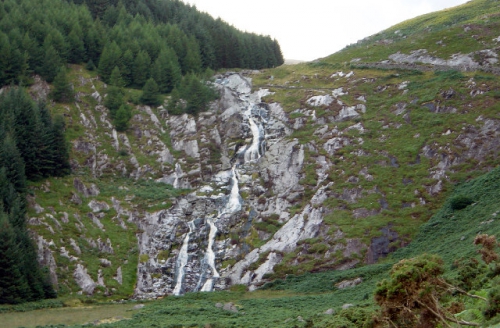
Event Location: The next Leinster League event will be on Sunday 6th November 2016 at Carraig Na Seabhac, Old Military Road, Co. Wicklow. Grid Reference: O 103 053.
Event Directions and Parking: If travelling from Dublin the event is approximately 9 km South of the Sally Gap on the Old Military Road. Parking is on a forest track. Please car-share if possible.
 Terrain: The competition area lies in the upper Glenmacnass river valley. One side of the valley is forested with thickets of young pine and scattered pine trees. The other side is open hillside. There is a lot of rock feature throughout. The valley is divided by a stream (the upper section of the Glenmacnass river) which is crossable by foot. The terrain underfoot varies from rough heather to grass. There are some forest rides in the wooded part of the competition area, but no paths on the open hillside. The valley sides are moderately steep.
Map: The map was surveyed in 2010-2011 by Pat Healy and partially updated in 2012, 2014 and 2016 . Maps are printed on water resistant material at a scale of 1:10,000 for all courses. Contour interval is 5 meters. Control descriptions for all courses will be available at registration and will also be printed on the map. Boulders less than 2m in height are generally marked on the map with the small boulder symbol. The large boulder symbol is used for boulders larger than 2m in height. The rock pillar symbol (black area symbol) is used for very large boulders. In very rocky areas boulders which seem small in relation to its neighbours are not generally mapped. Crags are mapped both with, and without tags. Dark green (fight) is used to mark pine thickets and young plantation. The semi-open screen is used to map scattered trees. Lone trees are marked with a green dot symbol.
Registration and Entry Fee: Enter at the event. Event registration is located beside the parking area. If you are new to orienteering please let the organisers know and they will show you what to do.
Adult: €8
Junior/Full-time student/Unwaged/OAP: €5
Family: €20
There will be a €2 surcharge for any participant who is not already a member of an orienteering club. The surcharge will be waived if the participant registers with Ajax Orienteers at the event. (Membership is free for the first year).
Timing: SportIdent (SI) timing will be used. SI cards are available for hire at event registration for €2. You must download your SI card after orienteering, whether you complete the course or not. Otherwise event organisers will not know if you have finished.
Start-times: 11:00 am – 1:00 pm.
Courses close: 2:30 pm
Start and Finish: The start for all courses is approximately 800m -1000m from the Parking Area. Access to the Start is along a public road and rough open terrain. Please take care when walking along the road. The route to the Start passes the Finish. The Finish for all courses is 500m – 700m from the parking area.
Event Officials:
Organiser: Paul
Controller: Donal Wickham
Planner: Aonghus O’Cleirigh
Course Details:
Brown – 8.1k, 275m
Blue – 6.0k, 210m
Green – 4.5k, 160m
Light Green – 2.7k, 130m
Red – 2.8k, 135m
Orange – 2.1k, 100m
Yellow – 1.7k, 85m
The courses are not buggy friendly. A forest ride used by the short courses is indistinct in places, and is marked by red and white tape. The Yellow course has one leg which is marked by red and white tape. The Brown, Blue and Green courses cross the Glenmacnass River. The other courses do not cross the river.
Competitor Safety: A cagoule (rain jacket) and whistle should be carried by each competitor. In the event of bad weather cagoules will be compulsory.
Acknowledgements: Thanks to Coillte and to Wicklow Mountain National Park for granting permission to hold the event. Please do not cause damage or litter.
21:02 | Permalink | Comments (0)
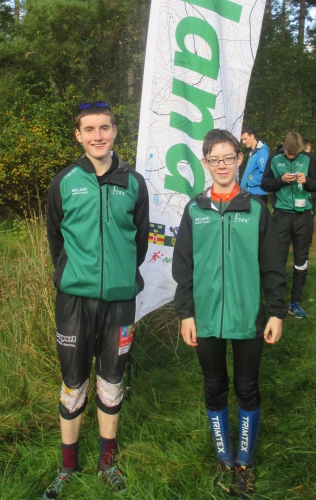
Oct 12, 2016
Ruairi and Oisin represent Ireland at the Junior Home International in Northumberland
21:27 | Permalink | Comments (0)
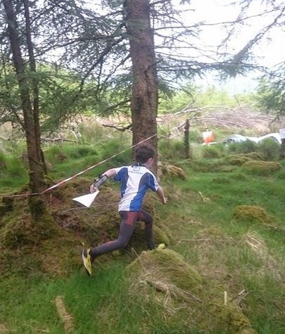
Jun 14, 2016
Cian at the Leinster 3-Day 2016
23:35 | Permalink | Comments (0)