
Leinster Orienteering Championships 2018
Ajax are proud organisers of the 2018 Leinster Orienteering Championships in the Vale of Clara & Ballinastraw, Rathdrum, County Wicklow on Sunday February 25th 2018.
About us
AJAX is an orienteering club based in Dublin, Ireland... More
IOA Policy
Ajax Orienteering Club implements the Irish Orienteering Association's anti-doping, anti-discrimination, child-protection and land-access policies, details of which are available on www.orienteering.ie
AJAX Child Safeguarding Statement (CSS)
AJAX Child Safeguarding Statement (CSS)
News
Ajax Committee 2023
Chairman:
John O'Donovan
Secretary:
Oisin Wall
Treasurer:
Mike Long
Mapping:
Paul
Children and Liaison:
Donal Wickham
Equipment:
John DeLacy
Webmaster:
Marcus Geoghegan
Did you know?
You can use RSS to keep up to date with changes to the website. Use the RSS link at the bottom of this column with your favourite RSS reader.
Contact Ajax
Our Photostream
We have set up a Flickr account so that club members can share their photos on line. It also allows photos to be displayed on this website.
Useful Links


Copyright on all material lies with Ajax Orienteering Club or the original copyright holders. Permission should be sought before use.
Mar 21, 2007
Congratulations!
Congratulation to our own Mike Long, on being second in the M40 class in the recent IMRA Winter League and seventh overall. Well done Mike!
10:30 Posted in Blog | Permalink | Comments (0)
Feb 20, 2007
Dublin Night Orienteering Championships
Bull Island, 24 February 2007
Final Details
Organisers:
Ajax Orienteering Club
Venue:
Bull Island, Clontarf, Co. Dublin
Travel Directions:
From M1/M50 junction: Take the M1 southbound towards the city centre to the end of the M1 at Whitehall (approx 3 km). At Whitehall church, turn left on to Collins Avenue West / Collins Avenue. Continue along this road for approx 3 km until it terminates at a T-junction in Killester. Turn left in Killester onto the Howth Road. After 300m turn right on to Castle Avenue. Continue downhill on Castle Avenue until you arrive at a roundabout. Turn right at the roundabout. After 150m turn left.
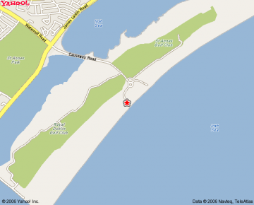
When you reach the coast road (Clontarf Road) turn left and follow it for 4 km until you reach the causeway road which leads to Bull Island; this is the only location that will be signposted. Turn right here and continue to the roundabout. Take the second exit (to the right) and registration is approximately 200m. Park on the right hand side. The map above shows the exact location.
Through Dublin City: Travel east along the North Quays until you reach the Point depot and turn left at the roundabout towards Dublin Port. After 1km turn right just before the railway bridge onto Alfie Byrne Road and follow the coast road until you see the Causeway Road to your right.
Map:
Maps will be premarked and bagged. Control Descriptions will be printed on the front of the map. The map is at 1:5000 scale with a 2.5m contour interval. The north lines on the map are aligned at 45° to the edge of the paper. The map is printed at A4 and does not include the southernmost part of the dunes. It was mapped in 2005/6 and used once before, for the Leinster Championships last year. Control Descriptions can be downloaded here.
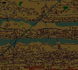
Terrain:
The terrain is made up of an area of very complex, low sand hills. The runability varies from fair to fast. There are many small paths which are marked on the map, however, most may be difficult to see in the dark. All courses cross several marshes, some of which are ankle deep. A line of telegraph poles running the length of the competition area has been omitted for clarity. There are several buildings, metal posts and bushes which will be very important for navigation.
Navigation will be very difficult at night and it is very important to keep in contact with the map at all times. Pace counting may be useful and conservative route choice is also advised.
Classes and Courses:
Instead of the usual classes, the following categories are available:
Mens Open
Womens Open
Junior Men (M16, M18 and M20)
Junior Women (W16, W18 and W20)
Veteren Men (M40 and M50)
Veteren Women (W40 and W50)
Supervet Men (M55+)
Supervet Women (W55+)
Intermediate
A - 5K - 17 controls - Mens Open and Womens Open
B - 3K - 12 controls - Junior Men, Junior Women, Veteren Men and Veteren Women (W40 and W50)
C - 2K - 9 controls - Supervet Men and Supervet Women
D - 2.3K - 6 controls - Intermediate
The A course loops a couple of times so it is very important to make sure that you are navigating towards the correct control.
The D course is a bit easier than the others and is designed for inexperienced orienteers.
Start Times:
Start times are from 19:00 to 20:00. The rugby match will finish a little after 19:00 so I suggest you arrange to watch it nearby. Don't overdo the celebrations as you will need all your wits about you!
Courses Close:
Courses close at 21:00 and it is very important that you report to the download station by then. Controls will be collected directly afterwards.
Fees:
Entry Fee - 8 euro
SI Rental - 2 euro
Safety & Weather:
Bull Island is very exposed to the elements so you should bring a whistle and cagule. If the weather is bad they may be compulsary.
Any competitor who becomes seriously disoriented or lost should head due North until they reach the assembly area.
You must download your SportIdent card, regardless of whether you finish or retire early - in this way the organisers know that you have finished. Competitors who do not download are not welcome at future Ajax Orienteering events.
SPORTident and GPS:
All courses use SPORTIdent. If you have a Garmin GPS receiver please bring it too.
Prizes:
There will be prizes for first place in all categories except Intermediate.
Start and Finish are adjacent to Registration and Download.
Litter:
It is an important condition of our access that we leave no litter. Please bring all your rubbish home with you. To this end, individual control description sheets will not be available. They will be printed on the front of the map and can be downloaded here.
21:25 Posted in Dublin Night Orienteering Championships | Permalink | Comments (0)
Jan 07, 2007
Dublin By Night 2007 Event 1
Ajax Orienteers are running the first event in this year's Dublin By Night series. This takes place this coming Tuesday in Killiney Hill Park. Full details are as follows:
| Date | 9th. Jan. 2007 |
| Planner/Organiser | Paul (Ajax) |
| Results/Timing | Martin Flynn (Ajax) |
| Location | Killiney Hill Park, Killiney, Co. Dublin. |
| Grid Ref. | O 262 260 |
| Signposting | From the junction of Avondale Road with Rochestown Avenue. |
| Directions | Follow Avondale Road from Rochestown Avenue. At the main roundabout (there is a smaller one halfway along) take the third exit on Barnhill Road. Take the second right onto Saval Park Road and continue to the end of the road. The entrance to the park is now opposite. An interactive map is also available at orienteering.ie |
| Start Times | 18:00-19:30. Courses close at 21:00. |
| Map | The map is drawn at a scale of 1:5000 with 5m contours. Some minor corrections have been made but the map is essentially unchanged from last years event. There will be no map corrections posted at the event. Competitors should note that the map uses a non-standard method of marking paths, which are shown as white or yellow corridors between areas of vegetation. Not all paths are marked but marked paths are generally clear and distinct. |
| General Info. | SportIdent timing will be in use. Bring your own card or rent one at registration. Competitors will need to complete a brief form at registration. Maps will be pre-printed and bagged with over-printed control descriptions. There are no map exchanges and or second maps on either course. Control descriptions will also be available at registration. Two courses are available, Long, 2.4 km, 145 m, 18 controls and Short, 1.6 km, 75 m, 11 controls. The courses have been planned with a view to maximising runability and enjoyment. As a result courses are a bit shorter than previously and a bit less technical. Please feel free to provide feedback (good and bad) after your run. Entry fee is €6.00 euros per competitor. |
Safety: Due to the terms of IOA insurance competitors who are under 16 years of age cannot be permitted to take part in this event. There are many high and steep cliffs on the map and although courses do not generally go close to these all competitors should exercise caution when near these areas. A first aid kit will be available at registration.
Orienteering is an adventure sport and competitors take part at their own risk and are responsible for their own safety.
Martin says: Bring your Garmin GPS, if you have one!
17:00 Posted in Event Notice | Permalink | Comments (0)
2006-7 Committee
The Club AGM took place on Thurs. Oct. 5th. in the Yellow House in Rathfarnham. The following committe were elected at that meeting:
| Chairman | Paul |
| Treasurer | Donal Wickham donalwickham(at)opw(dot)ie |
| Secretary | Jane Brennan janeaway2004(at)yahoo(dot)co(dot)uk |
| Mapping Officer | Aonghus O'Cleirigh aonghus_ocleirigh(at)yahoo(dot)com |
| Training Officer | Brendan O’Connor oconnorbrendan(at)gmail(dot)com |
| Webmaster | Paul |
| Child Protection Off. | Mike Long mikelong(at)ucd(dot)ie |
| Equipment Officer | John deLacey johndelacy(at)eircom(dot)net |
| Social Officer | Brendan O’Connor oconnorbrendan(at)gmail(dot)com |
15:39 | Permalink | Comments (0)
Nov 15, 2006
Angus Tyner (SET) grabs win in Ajax OC Featherbeds event
Results Link:
http://orienteering.ie/builder.php3?MoreResults-256
 Course set up was intended to keep people moving quickly across the
terrain and most of the times reflected this. Brown course overall
lead switched between 4 or 5 of the leaders and Angus Tyner (SET) moved into the lead over the only the last 2 or 3 controls pipping Declan McGrellis (LVO) by seconds. Ben Mangan (SET) put in an early very quick time on Light Green and 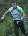 only Kevin O'Boyle (CNOC) got up close to him.
Photos by Martin Flynn: from top
Angus Tyner, Fiach O'Rourke, Roisin McDonnell
13:15 | Permalink | Comments (0)
Nov 07, 2006
Ajax Secretary goes Walkabout
13:30 | Permalink | Comments (0)
Sep 05, 2006
Ajax 1-2-3 at 2006 IMRA Navigation Challenge
A clean sweep for Ajax at this year's IMRA Navigation Challenge, a three-leg navigation race organised by Joe Lalor in Wicklow. It was a greuling series that really tested long-distance stamina and route choice. Each race had about 5 controls with grid references being handed out at the start time, mountain marathon style. Usually there was a long road and a shorter cross-country choice to be made.
Aonghus O'Cleirigh came first in a total time of 6'47", followed by Marcus Geoghegan in 8'10", with Andrew McCarthy in 8'21" making it a clean sweep for the Ajax men. We had no women competitors.
You can get more details by reading the race reports on the Irish Mountain Running website as follows:
Ballydonnell - Leg 1
http://www.imra.ie/?sec1=raceresult&id=381
Carrot&Stick - Leg 2
http://www.imra.ie/?sec1=raceresult&id=382
Stepping Stones - Leg 3
http://www.imra.ie/?sec1=raceresult&id=383
Animations of my routes and other runs are available in the mapping section of www.orienteering.ie
Marcus Geoghegan
September 5th 2006
15:45 | Permalink | Comments (0)