
Leinster Orienteering Championships 2018
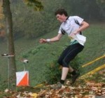
Ajax are proud organisers of the 2018 Leinster Orienteering Championships in the Vale of Clara & Ballinastraw, Rathdrum, County Wicklow on Sunday February 25th 2018.
About us
AJAX is an orienteering club based in Dublin, Ireland... More
IOA Policy
Ajax Orienteering Club implements the Irish Orienteering Association's anti-doping, anti-discrimination, child-protection and land-access policies, details of which are available on www.orienteering.ie
AJAX Child Safeguarding Statement (CSS)
AJAX Child Safeguarding Statement (CSS)
News
Ajax Committee 2023
Chairman:
John O'Donovan
Secretary:
Oisin Wall
Treasurer:
Mike Long
Mapping:
Paul
Children and Liaison:
Donal Wickham
Equipment:
John DeLacy
Webmaster:
Marcus Geoghegan
Did you know?
You can use RSS to keep up to date with changes to the website. Use the RSS link at the bottom of this column with your favourite RSS reader.
Contact Ajax
Our Photostream
We have set up a Flickr account so that club members can share their photos on line. It also allows photos to be displayed on this website.
Useful Links


Copyright on all material lies with Ajax Orienteering Club or the original copyright holders. Permission should be sought before use.
Oct 02, 2009
OK Paddy
 Marcus Geoghegan and Brendan O'Connor temporarily defected to OK Paddy for a few days of Orienteering in Roumania. Read about it here:
http://theirishorienteer.blogspot.com/2009/09/dracul-o.html
MG
09:45 | Permalink | Comments (0)
Sep 04, 2009
New Season Ajax
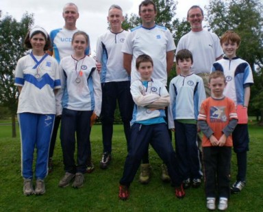
Here's a bunch of them already clocking up the kilometers at the Fingal event in Newbridge Demesne.
16:28 | Permalink | Comments (0)
Aug 25, 2009
Vale of Clara Nature Reserve
Here is status of the Cronybyrne map update. In an email to the Ajax eGroup I have asked the club's opinion on changing the name from “Cronybyrne” to “Vale of Clara Nature Reserve” and I would appreciate your comments on this (via the Ajax egroup).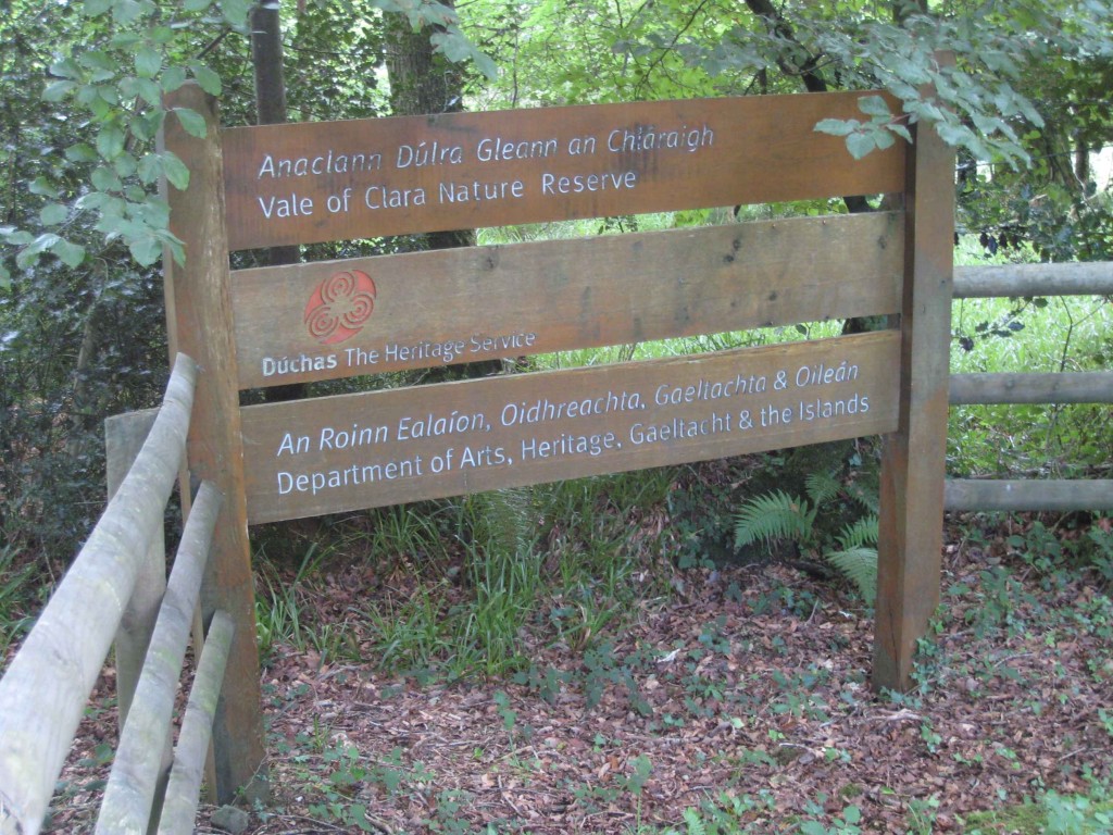
The Brown, Blue and Black features from the 1993 map have been vectorised in OCAD (contours, water, paths, crags, boulders, marshes etc). The final product will be a 1:10,000 map in portrait orientation.
I have re-surveyed about 25% of the area, mostly in the North-West corner; after a very slow start the re-survey is now going well and I expect to be finished before the end of September. I am only surveying areas to the east of the Avonmore river – there is a narrow strip of forestry on the west side that was on the old map, but the river is not crossable and there are no bridges. Ballinastraw is not included in this project.
Here is a pdf of the map so far; do not be deceived by the whiteness of it – many areas of yellow, green and green hatching have yet to be added.
My main findings so far are:
- The map is now nearly all broadleaf, but some small self-seeded coniferous areas remain.
- Some bramble has died - I think the high oak canopy has deprived it of enough light. However some areas of bramble remain and I am mapping these with symbol 409.0 "Undergrowth - Difficult to run" (closely spaced green lines). I haven't yet found any totally new area of bramble.
- The pre-dominant features on the forest floor are Fraochán bushes (aka Bilberry) and bracken ferns. In some areas the bracken is very high and difficult to traverse so I am mapping these areas with symbol 407.0 "Undergrowth - Slow Running" (widely spaced green lines), although the boundaries of these areas are vague.
- Many areas have high bracken at the edges, but a few metres in from the forest road, away from the light, this dies back to a more runnable forest floor. So a casual walk around the forest roads make the map seem more bracken-infested than it actually is.
- Most forest rides have disappeared. Some of the paths, and even roads, are becoming less distinct as the area reverts back to nature from it's previous commercial-forestry state.
- Most white-to-white vegetation changes have disappeared (i.e. thin dotted lines in areas of white indicating a vegetation change but not a change in runnability).
- The 1993 map had a lot of platform symbols on it (small brown triangles). This is no longer an ISOM standard and on Pat Healy's advice I am replacing these with small kinks in the contour lines to indicate spurs.
- The 1993 map had a lot of small “brown dot” knolls on it. Many of these were very small features to start with and now the change in the vegetation on the forest floor has made a lot of them effectively disappear. With great reluctance I am deleting some of them.
- Re-surveying some areas is really quick as these areas are essentially unchanged from the old map – it's just a matter of verifying that everything is the same.
- Re-surveying some areas is really slow as the vegetation has changed substantially. This is compounded by the disappearance of rides and vegetation changes and sometimes by high bracken.
- There are certainly enough areas of nice forest to stage very good Leinster League events, but course planners will need to be conscious of the undergrowth.
- There are some areas very suitable for junior and short courses, so both Brown/Blue and Orange/Yellow planning is equally feasible.
- There is good mobile phone coverage in most parts of the map.
- GPS coverage is surprisingly good – I have heard before that pine needles impede GPS reception while broadleaf coverage is not too disruptive and this theory seems to be holding true here.
- There is a new 110Kv power line across the bottom half of the map (not mapped yet), possibly serving the nearby Shering Plough chemical plant.
- As bracken is a significant feature of the area, it would probably be more suitable for Spring rather than Autumn events. However it is also a nature reserve and in order to build a good working relationship with the National Parks and Wildlife Service I think we should only look for permission for Autumn events to avoid bird nesting issues.
- There are no areas on the map that are suitable for parking cars; we will have to use the Coillte forestry above the road that bounds the map to the north. Regardless, I don't think the NPWS would give us permission to bring cars into the reserve and I don't think we should ask for it.
That's where it stands now and, all going well, in a couple of weeks I will be looking for people to check specific areas for me. This will involve visiting a defined small section and making sure that the map corresponds to what is on the ground. My rough estimate is that there will be 15 areas to be checked, each taking about 60 minutes. The area is north of Rathdrum, 50 minutes drive from Blackrock in Dublin. If you are available to help please email me at marcus dot geoghegan at gmail dot com.
The Vale of Clara Nature Reserve is a very special place, I think it is now a little-known wonder in south Wicklow. It is a pleasure to walk around it, especially early in the morning as it is teeming with wildlife. It is an integral part of the Dublin/Wicklow National Park.
The next time I visit the forest I will take some photos for this website
Marcus Geoghegan
10:44 | Permalink | Comments (0)
May 29, 2009
Ajax Juniors feature in National Champs
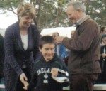 The Longs and O'Cleirighs finished in the top 3 on both days. Dara and Cathal took first place in M10 and M12 on day 1, and two third places on day 2.
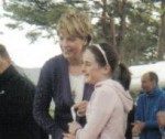
Ruari and Roisin both took 2nd place on Day 2 , Ruari in M10 and Roisin in W14.
Here's Ruari and Roisin getting their prizes from the Tanaiste Mary Coughlan.
16:17 | Permalink | Comments (0)
May 25, 2009
Niall Ewen moves to CNOC
 A big loss to AJAX, after many successful seasons as a junior, Niall's move to CNOC opens up a big opportunity for him as he heads for the Senior ranks.
With a big bunch of competitive runners in the same phase, the internal competition alone will test Niall and ensure he gets to make the most of his undoubted talent and personality.
It's a decision that signals he is looking to do the things it takes to move on. The orienteering scene in Ireland is unusual in looking less than favourably on a move of this kind, but as he lines up to run with his CNOC team mates he has one advantage, he has already wielded the knife to cut ties that might hold him back.
With a domestic season behind him that was frustrated with injury, he is playing catch up and the move to CNOC ties in well with a fresh return to the cycle of competition, training and searching for the next percentage improvement.
His old clubmates wish him well and who knows, as the wheel turns, in years to come there may be a slot in AJAX that has his name on it.
Peter Kernan
15:36 | Permalink | Comments (0)
May 18, 2009
IOC 2009 Medals Table
I was chatting to someone at the Irish Orienteering Championships prizegiving in Tawnawully who bemoaned the lack of medals that his club was receiving, so I simply couldn't resist putting the results into a spreadsheet to create an IOC2009 medals table.
A quick web search told me that the normal Olympic system ranks by number of golds, then silvers, then bronzes.
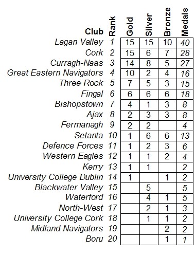 Using this rank-by-gold system CorkO ties with Lagan Valley, but loses out because Lagan Valley has a lot more silvers, so strength in depth won it for them. In fact in each category (gold, silver and bronze) Lagan Valley won the most medals.
Curragh-Naas are third, but if any one of Curragh-Naas's eight silvers had been a gold they would have moved up to second place overall, so a few seconds in any of several classes made all the difference. A number of competitors were entered as CNOC/DFO or DFO/CNOC; in each case I deleted the second club and assumed that the competitor represented the first - “count me twice” is definitely not allowed. I’m sure Curragh-Naas could scramble further up the table by redeploying their schizophrenic members (at the expense of the defence forces), but I’m just going by the club names in the published results.
There are two other possible systems: one ranks by total number of medals won and the other assigns points to medals. Both have problems – rank-by-medals means a gold has the same value as a bronze, and rank-by-points means N bronzes are equal to one gold, both of which go against the spirit of a championship event. You go there to win, not to nearly win, and I say that with genuine respect for all of those proud orienteering chests that are displaying an IOC2009 silver or bronze medal this week. However it has to be said that the rank-by-gold system used here does have a theoretical anomaly: what if club A wins only one gold and club B wins ten silvers but no golds; which club is better?
Whichever way you choose to look at it, Lagan Valley dominated the 2009 Irish Orienteering Championships. They took home about one of every five medals awarded, as well as one of every five golds. Only one third of their fifteen silvers was lost to clubmates, so they had great potential to win a lot more golds.
It is interesting that the top-three clubs won 55% of the golds and 45% of all medals; I think this means that big clubs win disproportionately more medals, possibly because they find it easier to fill relay teams.
Great Eastern Navigators are our best alchemists – they converted 62% of their 16 medals into gold, but Setanta seems to have lost the Midas touch with a conversion rate of only 8% from their 13 medals. Always the bridesmaid, never the bride...
The press didn't pick up on it, but Leinster actually beat Munster twice last weekend, once in Rugby and again in Orienteering. The inter-provincial gold share-out is: Leinster 41; Munster: 20; Northern Ireland 17; Connaught 1. However each of the top-three clubs in the medals table is from a different province which must mean that there is great potential to revive some sort of inter-provincial or all-Island inter-club competition. In total 20 different clubs brought home some silverware.
Medals from middle distance, classic distance and relay are all included and I have counted a relay team as one medal, not three - that’s the normal Olympic way of doing it. This table is based on medals, not places, as the eligibility rules preclude some class winners from receiving IOC medals. I'm sure that my spreadsheet and analysis is full of errors and apologies in advance for that.
Maybe we should have an IOC medals table each year? I can’t recall if this has ever been done before, but I certainly haven’t seen one in recent years. In an Irish Orienteering Championships we probably give out more medals than at an average Olympic games, so we must have enough data to build year-on-year comparisons. The data is up there on the web for the last few years so if anyone wants my spreadsheet (it's a pivot table) they are welcome to try and time-line the data across a few years.
Well done Lagan Valley.
Marcus Geoghegan
Ajax
09:51 | Permalink | Comments (0) | Tags: orienteering
May 12, 2009
Back to the Future
Marcus has slipped back in time into the analog world to gather up contours in the 1980s from Cronybyrne. When he comes back he’s going to turn them into 1’s and 0’s for us to use. This is his report to date…..
 Peter Gargan found the eight colour separations at 1:7500 that were sent to the printer in the '80s. They are Eoin Rothery masterpieces. I have talked to Pat Healy and he says that his 1993 revision just used the '80s map as a template with vegetation updates overlaid, so the brown (contour), black (road, boulder) and even most of the blue separations are still valid.
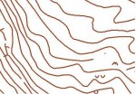
I have been experimenting with raster (bitmap) to vector-bezier (OCAD) conversion and have had great success on my trial scans with some software called wintopo. The picture shows some of Cronybyrne’s contours after conversion to OCAD vector format.
The colour separations have been professionally scanned by a friend of Brian Hollinshead who did a huge amount of large format high quality scanning for the Trinity map archive project. My next job is to convert the black, brown and blue into OCAD vector-bezier and we should have a good base to start updating green and yellow in field surveys. Of course the non-contour brown, the blue, and the black road/path network will need to be checked at the same time.
I hope to be able to report some progress in the next couple of weeks, although I would beg some patience from Ajax as May is the busiest time for me with my *two* IOA hats on.
16:18 | Permalink | Comments (0)